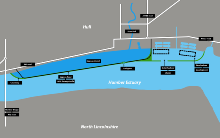
Lagoon Hull
The proposed lagoon would be formed from a stone causeway and will provide an outer lock gate in the Humber Estuary which would effectively dam the River Hull, making it a non-tidal waterway.
The 11-kilometre (6.8 mi) long causeway would also provide a dual carriageway from the A63 at Hessle which would run to Hull Docks, taking traffic away from the city centre.
An additional part of the scheme is to create a larger dock area which is protected from wave and tidal action, providing a safe haven for shipping.
[note 1][3] A tidal surge in 1969 prompted the development of the River Hull tidal surge barrier,[4] which only prevents flooding upstream of the barrier on the River Hull, whereas 90% of the city, and its foreshore environs, is 2 metres (6 ft 7 in) below the spring high-tide line.
[18] The proposal for the lagoon includes a new section of dual carriageway, that would connect with the A63 road near to the Humber Bridge, and run along the edge of the lagoon avoiding the centre of Hull, and connecting with the A63, the A1165 and the A1033 in the eastern part of Hull near the docks.