Lake Eyre basin
Most of the rivers in the Lake Eyre basin are now slow flowing, flat and completely dry for lengthy periods.
From that time on, as Australia drifted further north and the climate became gradually more arid, the lakes and floodplains started to dry.
Only in the last 2.6 million years did the onset of the ice ages bring about the present climatic regime and the consequent fairly rapid desertification of the area.
[8] During years of especially high rainfall, all the riverbeds in this vast, mostly flat, arid and semi-arid area lead inland (not towards the sea) towards Lake Eyre in central South Australia.
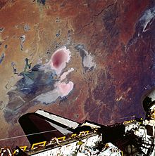
In flood years, it fills and, for a short time, undergoes a period of rapid growth and fertility: long-dormant marine creatures multiply and large flocks of waterfowl arrive to feed and raise their young before the waters evaporate once more.
Average annual rainfall in the area surrounding Lake Eyre is 125 millimetres (4.9 in), and the pan evaporation rate is 3.5 metres (11 ft).
Most of the water reaching Lake Eyre comes from the river systems of semi-arid inland Queensland, roughly 1,000 kilometres (620 mi) to the north.
To provide a sense of scale, the Lake Eyre Basin is about the size of France, Germany and Italy combined.
It is slightly larger than the Murray-Darling basin (which drains inland eastern Australia and is responsible for a large proportion of the continent's agricultural productivity) but has vastly less water.
Because the Lake Eyre Basin is almost flat, rivers flow slowly and frequently split up into floodplains or multiple braided channels.
The waters of the Finke disappear into the sands of the Simpson Desert and are not definitely known to ever make it as far south as Lake Eyre, although the story is told that this happened once early in the 20th century.
In this relatively humid northern area, rainfall can be as high as 500 millimetres (20 in) per year and evaporation as low as 2.4 metres (7 ft 10 in).
Australia's early bush poets immortalised the Diamantina River, making it a symbol of the remote outback.
It rises in the form of two central Queensland rivers, the Thomson between Longreach and Charters Towers, and the Barcoo in the area around Barcaldine, about 500 kilometres (310 mi) inland from Rockhampton.
[16] Indigenous Australians have lived with the cycles of the land for thousands of years and traditional owners are protective of its natural systems.
The Lake Eyre Basin Ministerial Forum was established as the decision making body responsible for overseeing of the Agreement.
[19] In 2009, the Queensland Environmental Protection Agency confirmed that heavy metals from mining operations near Mount Isa had entered the upper reaches of the Georgina River.
In 2014, the Queensland Government changed the laws protecting the rivers and floodplains, which, according to environmentalists, could lead to shale gas mining or fracking in the area.