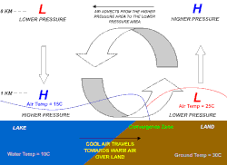
Sea breeze
Since land heats up much faster than water under solar radiation, a sea breeze is a common occurrence along coasts after sunrise.
Its speed depends on whether it is assisted or hampered by the prevailing wind, and the strength of the thermal contrast between land and sea.
Thunderstorms caused by powerful sea breeze fronts frequently occur in Florida, a peninsula bounded on the east and west by the Atlantic Ocean and Gulf of Mexico, respectively.
During the wet season, which typically lasts from June through September/October, any direction that the winds are blowing would always be off the water, thus making Florida the place most often struck by lightning in the United States,[4] and one of the most on Earth.
On calm summer afternoons with little prevailing wind, sea breezes from both coasts may collide in the middle, creating especially severe storms down the center of the state.
These thunderstorms can drift towards either the west or east coast depending on the relative strengths of the sea breezes, and sometimes survive to move out over the water at night, creating spectacular cloud-to-cloud lightning shows for hours after sunset.
In the southeast Australian states of New South Wales and Victoria, an intense sea breeze called the southerly buster[7] causes an abrupt, squally southerly wind change, with gusts in excess of 40 knots (74 km/h), in coastal cities such as Sydney in New South Wales south to Mallacoota, Victoria and Melbourne, as it approaches from the southeast, mainly on a hot day, bringing in cool, usually severe weather and a dramatic temperature drop, thus ultimately replacing and relieving the prior hot conditions.
Marking the boundary between hot and cool air masses, the southerly buster is sometimes represented by a roll-up cloud perpendicular to the coast.
The mountains create a channelling effect as the southerly gale winds move across the New South Wales coast, and frictional contrasts over the mainland and the ocean that disconnect the flow.