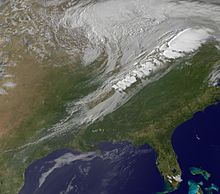
Cold front
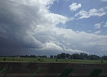
This often causes cloud formations with a strong vertical development, which may manifest as a line of showers and thunderstorms when enough moisture is present.
[1] On weather maps, the surface position of the cold front is marked with the symbol of a blue line of triangles/spikes (pips) pointing in the direction of travel.
[6] The other cloud types associated with a cold front depend on atmospheric conditions such as airmass stability and wind shear.
With significant airmass instability, vertically developed cumulus or cumulonimbus with showers and thunderstorms will form along the front.
After the passage of the cold front, the sky usually clears as high pressure builds in behind the system, although significant amounts of cumulus or stratocumulus, often in the form of long bands called cloud streets, may persist if the airmass behind the front remains humid from a source of moisture.
[8] Small and unchanging amounts of cumulus or cirrus clouds in an otherwise clear sky are usually indications of continuing fair weather as long as the barometric pressure remains comparatively high.
Wider rain bands can occur behind cold fronts which tend to have more stratiform, and less convective, precipitation.
If moisture is not sufficient, such as when a system has previously moved across a mountain barrier, cold fronts can pass without cloudiness.
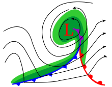
Mass continuity would require a vertical transport of air along the cold front where there is divergence (lowered pressure).
There are several factors that influence the final shape and tilt of the circulation around the front, ultimately determining the kind and location of clouds and precipitation.
When such a feature forms poleward of an extratropical cyclone, it is known as a trowal, which is short for TRough Of Warm Air aLoft.