Derecho
[5] The word was first used in the American Meteorological Journal in 1888 by Gustavus Detlef Hinrichs in a paper describing the phenomenon and based on a significant derecho event that crossed Iowa on 31 July 1877.
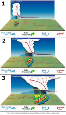
The resultant mesoscale convective system (MCS) often forms at the point of the strongest divergence of the upper-level flow, and new storm cells are developed in the area with the greatest low-level inflow.
[7][8] The convection tends to move east or toward the equator, roughly parallel to low-level thickness lines and usually somewhat to the right of the mean tropospheric flow.
During the cool season within the Northern Hemisphere, derechos generally develop within a pattern of mid-tropospheric southwesterly winds, in an environment of low to moderate atmospheric instability (caused by relative warmth and moisture near ground level, with cooler air aloft, as measured by convective available potential energy), and high values of vertical wind shear (20 m/s or 40 knots within the lowest 5 km or 16,000 ft of the atmosphere).
Warm season derechos in the Northern Hemisphere most often form in west to northwesterly flow at mid-levels of the troposphere, with moderate to high levels of thermodynamic instability.
[3] On January 11, 2022, the National Oceanic and Atmospheric Administration and Environment and Climate Change Canada formally revised the criteria for a storm to be classified as a derecho.
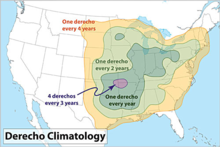
[citation needed] Datasets compiled by the United States National Weather Service and other organizations show that a large swath of the north-central United States, and presumably at least the adjacent sections of Canada and much of the surface of the Great Lakes, can expect winds from 40 to 55 m/s (75 to 105 kn) over a significant area at least once in any 50-year period, including both convective events and extra-tropical cyclones and other events deriving power from baroclinic sources.
Only in 40 to 65 percent or so of the United States resting on the coast of the Atlantic basin, and a fraction of the Everglades, are derechos surpassed in this respect — by landfalling hurricanes, which at their worst may have winds as severe as EF3 tornadoes.
Some upper-air measurements used for severe-weather forecasting may reflect this point of diminishing return for tornado formation, and the mentioned three situations were instances during which the rare Particularly Dangerous Situation severe thunderstorm variety of severe weather watches were issued from the Storm Prediction Center of the U.S. National Oceanic & Atmospheric Administration.
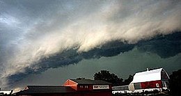
An area of convection developed across eastern Iowa near a weak stationary/warm front and ultimately matured, taking on the shape of a wavy squall line across western Ohio and southern Indiana.
[24] Since derechos occur during warm months and often in places with cold winter climates, people who are most at risk are those involved in outdoor activities.
[27] The storm was referred to as one of the largest "land-based hurricanes" in recorded history spawning 17 confirmed tornadoes across Wisconsin, Illinois, and Indiana.
Ten million acres of crops were damaged or destroyed, accounting for roughly a third of the state of Iowa's agricultural area.
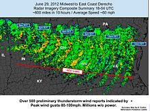
[30] Winds were confirmed as having stirred up in Colorado and Nebraska, and then proceeded in force crossing 5 states including Iowa, Minnesota, Illinois, Indiana, and Ohio leaving destruction in excess of $7.5 billion in estimated damages.
[31] The 21 May 2022 derecho in southern Ontario and western Quebec travelled lengthwise along the most heavily populated region in Canada, reaching peak wind speeds of 190 km/h.
[32] The derecho killed 10 people and caused $875 million property damage, the sixth largest "insured loss event" in Canadian history.