Leh–Manali Highway
[1] The Leh–Manali Highway acts as a trunk route for various India-China Border Roads in Ladakh and Himachal Pradesh.
The landscape changes after getting past the Atal tunnel and the greenery starts receding upon entering the Chandra river valley in the Lahaul region that lies in the rain-shadow.
After crossing Darcha, the greenery completely disappears and the mountain slopes on the leeward side become brown and arid.
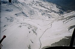
Most of the mountain peaks and highway Pass north of Darcha remain covered by snow even in summer and shine brightly in the sun.
The highway has many damaged stretches and under-maintained portions, where even a little rainfall can trigger dangerous landslides.
The road quality is poor from Zingzingbar to Pang and one has to drive carefully as high speed can cause discomfort.
There is scanty rainfall between Darcha and Leh even during the monsoon season in July–September as the entire region lies in rain shadow.
[5] The 130 km drive from Zingzingbar to Pang is the toughest part of the journey on the highway and a nightmare at times.
During the best of the season, without any blockades and traffic jams, it can take up to 5-6 hrs to cover this stretch with at least one halt en route.
The 175 km long road from Pang to Leh via Morey plains and Taglang La, is in excellent condition and generally takes less than 5 hours to cover.
However, it is now possible to cover the entire journey from Manali to Leh in 14–16 hours in a single day, if there are no road blockades and traffic jams en route.
The peak travel season is during May–June and September–October when tourists visit Atal tunnel, Rohtang pass, and Lahaul valley.
In an emergency, fuel may be available at villages and campsites en route (Jispa, Zingzingbar, Sarchu, Pang, etc.
Tent accommodations are also available in Darcha, Zingzingbar, Bharatpur (below Baralacha La pass, inhabited only during tourist season), and Pang.