Leitin
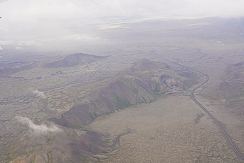
[2] When travelling on the hringvegur and looking to the west, the volcano is to be seen in a broad valley between the palagonite ridges of Lambafell [ˈlampaˌfɛtl̥] with its quarries and Sauðadalahnúkar [ˈsœyːðaˌtaːlaˌn̥uːkar̥] and behind some small cones, the Nyrðri [ˈnɪrðrɪ] and Syðri Eldborg [ˈsɪðrɪ ˈɛltˌpɔrk], eruptive vents of the Brennisteinsfjöll volcanic system.
[4] This small volcano produced an astonishing quantity of lavas reaching like a girdle over the peninsula of Reykjanes, entering the sea to the north next to the present capital city of Iceland Reykjavík as well as to the south in the bay of Selvogur.
This Elliðahraun travelled about 27 km down to today’s Reykjavík, and on its way it initiated explosions on a swamp or more probably on small lake which produced the rootless cone group Rauðhólar.
The same lava flow branch produced other interesting[editorializing] landforms like the group of hornitos, called Tröllabörn [ˈtʰrœtlaˌpœ(r)tn̥], some 10 km up the Hringvegur in the direction of Hellisheiði and again on its western side.
[9] Whereas the volcano itself is rather remote, some of its eruption products like the Rauðhólar rootless cone group or the Raufarhólshellir lava tube which can be visited with guided tours are well known visitor attractions.