Levelling
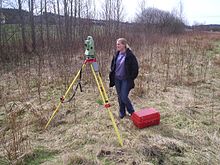
The complete unit is normally mounted on a tripod, and the telescope can freely rotate 360° in a horizontal plane.
The surveyor looks through the eyepiece of telescope while an assistant holds a vertical level staff which is graduated in inches or centimeters.
The difference between these two readings equals the change in elevation, which is why this method is also called differential levelling.
The closure check guards against blunders in the operation, and allows residual error to be distributed in the most likely manner among the stations.
Some instruments provide three crosshairs which allow stadia measurement of the foresight and backsight distances.
Turning is a term used when referring to moving the level to take an elevation shot from a different location.
To "turn" the level, one must first take a reading and record the elevation of the point the rod is located on.
This is done by using a total station, or any other instrument to read the vertical, or zenith angle to the rod, and the change in elevation is calculated using trigonometric functions (see example below).
For most work it is sufficient to keep the foresight and backsight distances approximately equal so that the refraction and curvature effects cancel out.
[5] The dumpy level was developed by English civil engineer William Gravatt, while surveying the route of a proposed railway line from London to Dover.
Dumpy levelling requires shorter and therefore more numerous sights, but this fault is compensated by the practice of making foresights and backsights equal.
The compensator consists of small prisms suspended from wires inside of the level's chassis that are connected together in the shape of a pendulum.
This allows for only horizontal light rays to enter, even in cases where the telescope of the instrument is not perfectly plumb.
[6] The surveyor sets the instrument up quickly and does not have to re-level it carefully each time they sight on a rod on another point.
It also reduces the effect of minor settling of the tripod to the actual amount of motion instead of leveraging the tilt over the sight distance.
Because the level of the instrument only needs to be adjusted once per setup, the surveyor can quickly and easily read as many side-shots as necessary between turns.