Lewis and Clark Pass
The furrows left by the countless dog and horse travois that crossed the pass are still visible (though fading), and it is one of the few places along the expedition's route where visitors may still encounter a grizzly bear.
On a clear day, visitors to the pass can see Square Butte in Cascade County, Montana, 40 miles (64 km) to the northeast.
[3] The Nez Perce guides for Meriwether Lewis in 1806 referred to the pathway over the pass as the "Buffalo Road" or the "Cokahlarishkit" trail.
Rogers Pass, 5.3 miles (8.5 km) to the southwest crosses the continental divide at an elevation 800 feet (240 m) lower, and is part of Montana Highway 200.
However Lewis and Clark is the pass with the easiest approaches to the summit over which Native people could travel, using dog and later horse travois.
On the westward leg of their expedition to the Pacific Ocean in 1805, Lewis and Clark were unaware of the pass, but by the time of their return they had learned of it from local tribal people and were determined to travel over it.
On July 1, 1806, at Traveler's Rest on Lolo Creek in the Bitterroot Valley, Lewis and Clark split into two separate parties.
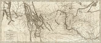
[3][5] On July 7, 1806, late in the day, Lewis and his small party came to the top of the divide between the Blackfoot River and the Dearborn.
Lewis said little about the area other than that he could see in the far distance, on the skyline of the eastern Montana plains, the landmark now called Square Butte which the Corps had dubbed "Fort Mountain" the previous July.
[2] The town of Lincoln is located 58 miles northwest of Helena, Montana, on Highway 200 and is a full service community.