Further, there is no agreed standard criterion for what amount of differences in vocabulary, grammar, pronunciation and prosody are required to constitute a separate language, as opposed to a mere dialect.
At some point in time, starting about 4000 BCE (6000 BP), this population expanded through migration and cultural influence.
Indo-European languages continued to be spoken in large land areas, although most of western Central Asia and Asia Minor were lost to other language families (mainly Turkic) due to Turkic expansion, conquests and settlement (after the middle of the first millennium AD and the beginning and middle of the second millennium AD respectively) and also to Mongol invasions and conquests (which changed Central Asia ethnolinguistic composition).
However, from about AD 1500 onwards, Indo-European languages expanded their territories to North Asia (Siberia), through Russian expansion, and North America, South America, Australia and New Zealand as the result of the age of European discoveries and European conquests through the expansions of the Portuguese, Spanish, French, English and the Dutch.
(These peoples had the biggest continental or maritime empires in the world and their countries were major powers.)
[3] Using a mathematical analysis borrowed from evolutionary biology, Donald Ringe and Tandy Warnow propose the following tree of Indo-European branches:[4] David W. Anthony, following the methodology of Donald Ringe and Tandy Warnow, proposes the following sequence:[4] The list below follows Donald Ringe, Tandy Warnow and Ann Taylor classification tree for Indo-European branches.
[5] quoted in Anthony, David W. (2007), The Horse, the Wheel and Language: How Bronze-Age Riders from the Eurasian Steppes Shaped the Modern World, Princeton University Press.
Anatolian languages
in 2nd millennium BC; Blue:
Luwian
, Yellow:
Hittite
, Red:
Palaic
.
Tocharian languages
:
A
(blue),
B
(red) and
C
(green) in the Tarim Basin.
[
10
]
Tarim oasis towns are given as listed in the
Book of Han
(c. 2nd century BC). The areas of the squares are proportional to population.
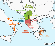
Distribution of modern
Albanian dialects
.
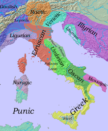
Iron Age Italy (c.500 B.C.).
Italic languages
in green colours.
Length of the Roman rule and the Romance Languages
[
15
]
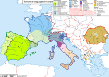
Romance languages in Europe
(major dialect groups are also shown).
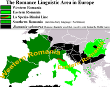
European extent of Romance languages in the 20th century
Eastern and Western Romance areas split by the
La Spezia–Rimini Line
; Southern Romance is represented by Sardinian as an outlier.
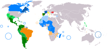
Romance languages in the World
. Countries and sub-national entities where one or more Romance languages are spoken. Dark colours: First language, Light colours: Official or Co-Official language; Very Light colours: Spoken by a significant minority as first or second language. Blue:
French
; Green:
Spanish
; Orange:
Portuguese
; Yellow:
Italian
; Red:
Romanian
.
Diachronic distribution of
Celtic language speakers
:
A map of the modern distribution of the
Celtic languages
. Red:
Welsh
; Purple:
Cornish
; Black:
Breton
; Green:
Irish
; Blue:
Scottish Gaelic
: Yellow:
Manx
. Areas where languages overlap are shown in stripes.
The distribution of
major modern Greek dialect areas
.
Anatolian Greek until 1923
.
Demotic
in yellow.
Pontic
in orange.
Cappadocian
in green. Green dots indicate Cappadocian-Greek-speaking villages in 1910.
[
20
]
Armenian dialects
, according to Adjarian (1909) (before 1st World War and Armenian Genocide). In many regions of the contiguous area shown in the map, Armenian speakers were the majority or a significant minority.
Modern geographical distribution of the
Armenian language
.
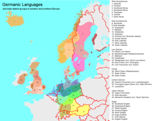
One proposed theory for approximate distribution of the primary
Germanic
dialect groups in Europe around the year 1 AD.
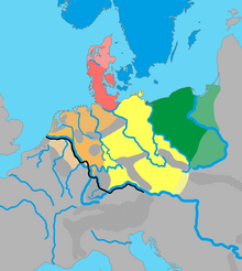
East Germanic
Germanic languages and main dialect groups in Europe after 1945
.
Germanic languages in the World
. Countries and sub-national entities where one or more Germanic languages are spoken. Dark Red: First language; Red: Official or Co-Official language, Pink: Spoken by a significant minority as second language.
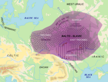
Area of
Balto-Slavic dialect continuum
with proposed material cultures correlating to speakers Balto-Slavic in Bronze Age .
Red
dots= archaic Slavic hydronyms.
Political map of Europe with countries where a
Slavic
language is a national language marked in shades of green and where a
Baltic
language is a national language marked in light orange. Wood green represents
East Slavic
languages, pale green represents
West Slavic
languages, and sea green represents
South Slavic
languages. Contemporary Baltic languages are all from the same group:
Eastern Baltic
Baltic languages
(extinct languages shown in stripes).
Slavic languages
in Europe . Areas where languages overlap are shown in stripes.
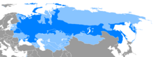
Russian Language
– Map of all the areas where the
Russian language
is the language spoken by the majority of the population. Russian is the biggest
Slavic
language both in number of
first language
speakers and in geographical area where the language is spoken .
Geographic distribution of modern
Indo-Iranian languages
. Blue, dark purple and green colour shades:
Iranic languages
. Dark pink:
Nuristani languages
. Red, light purple and orange colour shades:
Indo-Aryan languages
. Areas where languages overlap are shown in stripes.
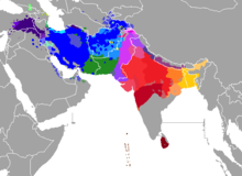
Present-day geographical distribution of the major
Indo-Aryan language groups
.
Romani
,
Domari
,
Kholosi
and
Lomavren
are outside the scope of the map. Colours indicate the branches – yellow is
Eastern
, purple is
Dardic
, blue is
Northwestern
, red is
Southern
, green is
Western
, brown is
Northern
and orange is
Central
. Data is from
"The Indo Aryan Languages"
as well as census data and previous linguistic maps.
Dardic