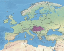
Pannonian Basin
The East Slavic languages, namely Ukrainian, use the terms Tysa-Danube Lowland or Middanubian Lowland (Ukrainian: Тисо-Дунайська низовина, Середньодунайська низовина) Pannonian basin vs Carpathian basin: On the territory of present-day Hungary the ancient Roman Pannonia province was located only on Transdanubian territories, however the Great Hungarian Plain was not part of Pannonia province.
The largest plain of Ancient Roman Pannonia province is located in Slavonia in Croatia and Voivodine in modern Serbia.
Julius Pokorny derived the name Pannonia from Illyrian, from the Proto-Indo-European root *pen-, "swamp, water, wet" (cf.
[5] The name "Carpates" is highly associated with the old Dacian tribes called "Carpes" or "Carpi" who lived in a large area from the east, northeast of the Black Sea to the Transylvanian Plain in present day Romania and Moldova.
The name Carpates may ultimately be from the Proto Indo-European root *sker-/*ker-, which meant mountain, rock, or rugged (cf.
It extends roughly between Vienna in the northwest, Košice in the northeast, Zagreb in the southwest, Novi Sad in the south and Satu Mare in the east.
[citation needed] The Danube enters the basin from its northwest through a valley that splits the Alps and the Bohemian Forest.
It runs through the center of the basin escaping at southeast portion where South Carpathians transition to Dinaric Alps and Balkan Mountains.
Another important river of the region is Sava which running along the eastern foothills of the Dinaric Alps together with the Danube forms a conditional northern limit of Balkan peninsula.
When archaeologists come upon objects of obsidian or chert, copper or gold, they have almost unparalleled opportunities to interpret ancient pathways of trade.
After the Battle of Mohács in 1526, the central and eastern regions of the kingdom and the plain on which they lay were incorporated into the Ottoman Empire, while the remainder to the north-west was subsumed into the holdings of the Habsburg monarchy and retitled Royal Hungary.
With the dissolution of Austria-Hungary after World War I, the region was divided between Hungary, Romania, Czechoslovakia, Austria and the Kingdom of Serbs, Croats and Slovenes (renamed to Yugoslavia in 1929).
The borders drawn in 1918 and 1919 are mostly preserved as those of the contemporary states of Austria, Czech Republic, Hungary, Poland, Slovakia, Serbia, Ukraine, Croatia, and Romania.