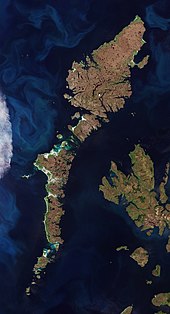
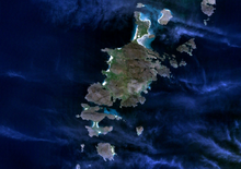
List of Outer Hebrides

The Outer Hebrides is a chain of more than 100 islands and small skerries located about 70 kilometres (43 mi) west of mainland Scotland.

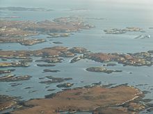
To the south across the Sound of Harris lie the Uists and Benbecula, which were joined by a series of causeways constructed between 1940 and 1960 to improve transport links.

[9] The definition of an island used in this list is that it is "land that is surrounded by seawater on a daily basis, but not necessarily at all stages of the tide, excluding human devices such as bridges and causeways".

Ensay, Kisimul Castle and Eilean na Cille are "included in the NRS statistical geography for inhabited islands but had no usual residents at the time of either the 2001 or 2011 censuses".

On 4 May 1746, Bonnie Prince Charlie hid on Eilean Liubhaird with some of his men for four days whilst Royal Navy vessels patrolled the Minch.

For example, Haswell-Smith (2004) treats Eileanan Iasgaich[Note 11] as a single island of 50 ha, although during high tides it becomes several tidal islets—none of which is ever connected to the "mainland" of South Uist.

The islet on which Kisimul Castle stands is the ancient seat of Clan MacNeil and Shillay in the Monach Isles had a staffed lighthouse until 1942.

[28] The tiny Beasts of Holm of the east coast of Lewis were the site of the sinking of the Iolaire during the first few hours of 1919,[29] one of the worst maritime disasters in United Kingdom waters during the 20th century.

Calvay in the Sound of Barra provided the inspiration for Compton MacKenzie's 1947 novel Whiskey Galore after the SS Politician ran aground there with a cargo of whisky.

[30] Smaller islands grouped geographically: Ceann Loch Resort to Aird Dhrolaige: Liongam, Staca Liath There are various small archipelagos within the Outer Hebrides.

A map of the island chain of the Outer Hebrides that lie to the west with numerous other islands—the Inner Hebrides—closer to the mainland of Scotland in the east.
The Hebrides . The Outer Hebrides (in orange) lie to the west with the Inner Hebrides closer to the mainland of Scotland in the east.
Satellite pictures of Outer Hebrides
Still blue water in the foreground with numerous small coloured boats along a harbour and buildings against a blue sky in the background
The harbour, Stornoway
The ruins of a double-walled circular stone tower on top of a green hillock with a blue sky in the background
The ruins of Dun Carloway Iron Age broch
Four gold-coloured chess pieces sit on a glass shelf with a red wall in the background. All four pieces are seated and wear crowns. Two of the pieces are larger and have beards, the other two are female figures.
Two kings and two queens from the Lewis chessmen
A large stone statue of a tall and slender woman by a field. The woman has long hair and wears a hat and carries a child on her shoulders.
Our Lady of the Isles, South Uist
A small white building is barely visible on top of dark and imposing cliffs with deep blue water at their base.
The lighthouse atop the cliffs of Sloc na Bèiste, Barra Head
A small concrete pillar sits amongst long grass. There is a body of water in the background.
Cnoc Bhàrr on Ceann Iar is the highest point of the Monach Islands at only 19 metres (62 ft). Shillay can be seen in the distance.
A grass-covered driveway leads between two stone pillars with orange lichen on their pyramid-shaped tops. Beyond is a stone building with ruined outhouses and green hills with a blue sky in the background
Ruins of the old school house, Mingulay
A small blue sailing dinghy lies in an aquamarine body of water next to a rocky shore underneath light blue skies. Three people are swimming off the stern of the boat next to a red buoy.
Hintinish Bay, Hellisay in summer
A large, dark green island seen from above is surrounded by smaller islands in a dark blue body of water. Wispy clouds partially obscure the view.
Barra from space. Eriskay is to the north at the top, with Fiaraidh , Fuday , Orosay , Gighay and Hellisay further south in the Sound of Barra. Sandray and Vatersay are to the south of Barra itself.
Two dark green areas of land are separated from one another by a shallow and narrow strait. There are small islands in the distance under white clouds.
Orosay from the air, with Gighay and Hellisay beyond.
A green hill ends in dark brown cliffs over blue water.
The western cliffs of Mingulay with the stack of Arnamuil at centre
Grey hills back green moors beyond a grey body of water. A small island is separated from the cliffs of the shore by a deep chasm.
Beinn Mhòr and Thacla in the distance and Dùn Othail and Nicholson's Leap in the foreground
Islands in Loch Uisgebhagh. Bearran is at top right, Orasaigh, middle right and the peninsula of Meanais at top left. Eilean nan Each, Maragaidh Beag and Maragaidh Mòr are in the distance.
A rocky shoreline on a cloudy day. The outline of a building is just visible at left.
Haskeir Lighthouse, with Haskeir Eagach in the distance
An indistinct image from space of brown and green islands in dark blue water.
North Uist and surrounding islands. The Monach Isles are at left, Pabbay in the Sound of Harris is at top centre, Loch Maddy and narrow Loch Euphort at right
A tall, conical grey tower with outbuildings sits in a green field. A second small, white tower is in the background.
The lighthouse on Shillay
A narrow metal bridge crosses a steep gorge
The bridge connecting Dùn Èistean to Lewis
A black and white image of a twin-masted motor yacht with a funnel afloat with no sails set.
Admiralty yacht HMS Iolaire , sunk with the loss of 205 lives on the Beasts of Holm skerries near the entrance to Stornoway harbour in 1919. [ 29 ]