List of crossings of the Hackensack River
The Hackensack River courses southward for approximately 50 miles (80 km)[4] in Rockland County, New York in the north and Bergen and Hudson counties in northeastern New Jersey to the south, forming the border of the latter two for part of its length.
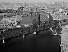
By the early 1900s conflicts between rail and maritime traffic led to calls for changes in regulations giving priority to trains.
[9] At one time, Van Buskirk Island, created in 1804, was the head of navigation, but freshwater flow in the Hackensack has been diminished by construction of dams,[10] namely the Oradell (1923), the DeForest (1952), and the Tappan (1972).
[14] which at one time was a major waterway for towboats and river barges in the Port of New York and New Jersey.
[17] The Lower Hackensack remains partially in use for commercial maritime traffic, notably for sewage sludge for treatment at a facility on the bay.