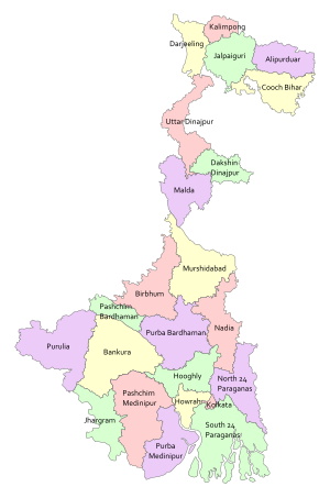
List of districts of West Bengal
Other districts are further divided into administrative units such as subdivisions and blocks, administered by SDO and BDO, respectively.
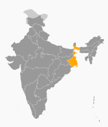
West Bengal is bordered by three countries: Nepal, Bhutan and Bangladesh; and five Indian states: Sikkim, Bihar, Jharkhand, Odisha, and Assam.
Sikkim and Bhutan are located to the north of the state, Nepal to the northwest, Bihar and Jharkhand in the west, Odisha in the southwest, the Bay of Bengal to the south, and Bangladesh and Assam are in the east.
[14] The districts on the south of the Ganges—Bankura, Paschim Bardhaman, Purba Bardhaman, Birbhum, Purulia, Murshidabad, Nadia, West Midnapore, Jhargram, East Midnapore, Hooghly, Howrah, Kolkata, North 24 Parganas and South 24 Parganas—constitute a variety of geographical regions such as the Rarh region, the Western plateau and high lands, the coastal plains, the Sunderbans and the Ganga Delta.
The uninhabited South Talpatti Island, which surfaced in the Bay of Bengal in the 1970s near the Indo-Bangladesh border, is claimed by both India and Bangladesh.
[15] After India gained independence in 1947, the province of Bengal was partitioned along religious lines.
The western part remained in India (and was named West Bengal) while the eastern part joined newly formed Pakistan as a province called East Pakistan (later giving rise to Bangladesh in 1971).
[2] At the time of its creation in 1947, the state of West Bengal was divided into 14 districts—Bankura, Birbhum, Burdwan, Calcutta (Kolkata), Darjeeling, Jalpaiguri, Hooghly, Howrah, Malda, Midnapore, Murshidabad, Nadia, West Dinajpur and 24 Parganas.
Transfer of administration was started on 12 September 1949 and was completed on 19 January 1950, when Cooch Behar became a district of West Bengal.
Formally, it joined India in 1952 and finally became a part of the Hooghly district of West Bengal on 2 October 1954.
[19] Since 2007, the demand for a separate Gorkhaland state has been revived by the Gorkha Janmukti Morcha and its supporters in the Darjeeling hills.
[27] Gorkha Hill Council manages the departments of Public Health, Education, Public Works, Transport, Tourism, Market, Small scale industries, Agriculture, Agricultural waterways, Forest (except reserved forests), Water, Livestock, Vocational Training and Sports and Youth services.
[28] District administration of Darjeeling, which is still responsible for election, panchayat, law and order, revenue etc., also acts as an interface between the Council and the State Government.
West Bengal is now divided in twenty three districts, grouped under five divisions:[9] The following is a list of the basic demographic data for the districts of West Bengal at the time of the 2011 census by their population rank in India[38] The following is a list of basic economic data for the districts of West Bengal as of 2023–2024, the latest year for which data is available:[39]