List of unmanned aerial vehicle applications
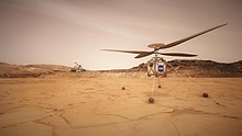
[6] A number of advantages of a viable rotorcraft design were noted, including the ability to pass over difficult Mars terrain yet still visit multiple sites in situ.
[16] The Tu-123 "Hawk" is a supersonic long-range reconnaissance UAV intended for conducting photographic and signals intelligence to a distance of 3200 km; it was produced beginning in 1964.
[26] Islamic State of Iraq and the Levant have used drones, adapting UAVs bought online, to drop explosives, primarily using quadcopters.
[36] Since January 2016 British scientists are developing UAVs with advanced imaging technology to more cheaply and effectively map and speed up the clearing of minefields.
John Fardoulis, project researcher from Bristol University states that "the maps [their] UAVs will generate should help deminers focus on the places where mines are most likely to be found".
Their intended UAVs will be able to perform flyovers and gather images at various wavelengths which, according to Dr John Day from the University of Bristol, could indicate explosive chemicals seeping from landmines into the surrounding foliage as "chemicals in landmines leak out and are often absorbed by plants, causing abnormalities" which can be detected as "living plants have a very distinctive reflection in the near infrared spectrum, just beyond human vision, which makes it possible to tell how healthy they are".
[40] Civil uses include aerial crop surveys,[41] aerial photography,[41] search and rescue,[41] inspection of power lines and pipelines,[42][43] counting wildlife,[42] delivering medical supplies to otherwise inaccessible regions,[44] and detection of illegal hunting,[45] reconnaissance operations,[43][46] cooperative environment monitoring,[47] border patrol missions,[43][48] convoy protection,[49] forest fire detection and monitoring,[43] surveillance,[43][50] coordinating humanitarian aid,[51] plume tracking,[52] land surveying,[53] fire and large-accident investigation,[53] landslide measurement,[53] illegal landfill detection,[53] the construction industry,[54] smuggling,[55] and crowd monitoring.
Small UAVs helped researchers produce three-dimensional models of Peruvian sites instead of the usual flat maps – and in days and weeks instead of months and years.
In 2013, UAVs flew over Peruvian archaeological sites, including the colonial Andean town Machu Llacta 4,000 m (13,000 ft) above sea level.
[62][63] On 6 February 2017 it was reported that scientists from the UK and Brazil discovered hundreds of ancient earthworks similar to those at Stonehenge in the Amazon rainforest with the use of UAVs.
[69] In 2014, the prime minister of the United Arab Emirates announced that the UAE planned to launch a fleet of UAVs[70] to deliver official documents and supply emergency services at accidents.
[76] UAV usage in conservation is able to alleviate many of the challenges facing conservationists on foot, such as "the large size of species’ geographic ranges, low population densities, inaccessible habitat, elusive behavior and sensitivity to disturbance.
[78] A whale conservation UAV capable of collecting blowhole mucus into a sterile petri dish was put into use in January 2018 following its development by researchers at Macquarie University in Sydney, Australia.
In June 2012, World Wide Fund for Nature (WWF) announced it would begin using UAVs in Nepal to aid conservation efforts following a successful trial of two aircraft in Chitwan National Park.
[91] In March 2013, the British League Against Cruel Sports announced that they had carried out trial flights with UAVs and planned to use a fixed-wing OpenRanger and an "octocopter" to gather evidence to make private prosecutions against illegal hunting of foxes and other animals.
The idea is to circumvent ag-gag prohibitions by keeping the UAVs on public property, but equipping them with cameras sensitive enough to monitor distant activities.
[96] A 2018 review identified three roles for UAVs in healthcare: While other uses are being researched, such as their use for larval source management (LSM) to control vectors of diseases like malaria.
In localities such as Los Angeles and New York, authorities have actively interceded to shut down UAV filmmaking over safety or terrorism concerns.
[100][101][102] In June 2014, the FAA acknowledged that it had received a petition from the Motion Picture Association of America seeking approval for the use of UAVs for aerial photography.
Seven companies behind the petition argued that low-cost UAVs could be used for shots that would otherwise require a helicopter or a manned aircraft, saving money and reducing risk for pilot and crew.
In the United States, hobby and recreational use of such UAS is permitted (a) strictly for hobby or recreational use; (b) when operated in accordance with a community-based set of safety guidelines and nationwide community-based organizations; (c) when limited to not more than 55 pounds (with exceptions); (d)without interfering with and giving way to any manned aircraft; and (e) within 5 miles of an airport only after notifying air traffic control.
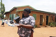
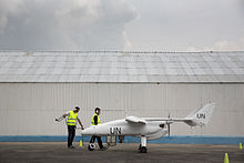
[128] In August 2013, the Italian defence company Selex ES provided an unarmed surveillance UAV to the Democratic Republic of Congo to monitor movements of armed groups in the region and to protect the civilian population more effectively.
Beyond the standard barometric pressure and temperature data typically culled from manned hurricane hunters, the Aerosonde system provides measurements from closer to the water's surface than before.
In 2012, Cavim, the state-run arms manufacturer of Venezuela, claimed to be producing its own UAV as part of a system to survey and monitor pipelines, dams and other rural infrastructure.
Their idea specifies using the technology with UAVs: Equip unmanned aerial vehicles with an extinguisher that works through soundwaves and send them into fires that are too dangerous for people to enter.
[133] T-Hawk[147] and Global Hawk[148] UAVs were used to gather information about the damaged Fukushima Number 1 nuclear plant and disaster-stricken areas of the Tōhoku region after the March 2011 tsunami.
NDVI images, generated with a near-IR sensor, can provide detailed information on crop health, improving yield and reducing input cost.
In construction, drones can be used to survey building sites to help monitor and report progress, spot errors early on and avoid rework and show off finished projects in marketing materials.
UAVs equipped with LED's can be used to give a nighttime aerial display, for example Intels "Shooting star" UAV system used by Disney and Super Bowl 2017 halftime show[161] In Thailand, a locally developed software were created to organize light shows in celebration of the coronation of King Vajiralongkorn in 2019, and various royal observances afterward.
A project of the Australian Department of Defense aims to detect hotspots by measuring body temperatures of people in public with infrared cameras.