Little River (Tennessee)
[a] Deep within Cherokee territory, the detachment withdrew after hearing rumors of a superior force approaching, perhaps organized by John Watts.
[7]: 343–346 [9] The 1791 Treaty of Holston established the northeastern border of the Cherokee Nation with the United States of America at the ridge separating the Little River and Tennessee basins.
[10][11] In late 1791,[12] Cherokee emissaries traveled to Philadelphia, America's then-capital, in part to request that settlers who had intruded south of the ridge be removed.
Henry Knox, the secretary of war, supported this request, and also recommended moving troops from Georgia to the ridge to enforce the treaty's provisions.
[14][15] Little River rises in Sevier County inside the national park on the north slope of Kuwohi, the highest point in Tennessee.
Kuwohi is located directly on the Tennessee-North Carolina state line, which parallels the Appalachian Trail along the crest of the Smokies.
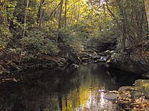
This section of the river is navigable by expert kayak and canoe enthusiasts and offers excellent fishing for native brook trout.
About midway between Gatlinburg and Townsend, Little River enters a relatively flat area known as Metcalf Bottoms, which developed along an oasis of soft phyllite amidst the more predominant sandstone.
Continuing to follow TN 73 the stream crosses into Blount County en route to its confluence with Middle Prong of Little River at an area known as the "Townsend Y".
Just past the Y, Little River exits the Great Smoky Mountains National Park into Tuckaleechee Cove and Townsend.
From this point forward, with the exception of two old mill dams, the Little River can be navigated in a kayak at normal water levels.
Three decades ago it was largely undeveloped, with a few small "mom and pop" style hotels and restaurants; now major chains have built larger lodging facilities, although not yet comparable to Gatlinburg or Pigeon Forge.
The Townsend area was once the site of many scenic swinging bridges over Little River; liability concerns have caused most of these to be dismantled in recent years.
As it steadies, the river no longer displays the extreme clarity and attractive rocky bottom of its upper reaches and resembles a more typical stream in a moderately rolling, somewhat rural area.
These three creeks are considered "impaired", contributing to a designation of Little River as "threatened" by the Tennessee Department of Environment and Conservation.