Loch Gair Hydro-Electric Scheme
Profits made by selling bulk electricity to the Scottish lowlands would be used to fund "the economic development and social improvement of the North of Scotland."
The deputy chairman and chief executive was Edward MacColl, an engineer with wide experience of hydro-electric projects and electrical distribution networks.
[8] When the North of Scotland Hydro-Electric Board was created, a panel of architectural advisors was set up, consisting of Reginald Fairlie, Harold Tarbolton and James Shearer.
This prehistoric structure was excaved by Mr and Mrs J G Scott in July and August of that year, before water levels were raised again in the autumn of 1961.
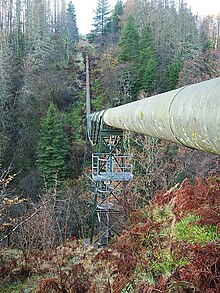
[13] The dam is a relatively small mass gravity structure,[12] completed in 1961 with a maximum height of 24 metres (79 ft),[14] from which water reaches the turbine house through a tunnel and a pressure pipeline at the lower end.
[15] Loch Glashan is fed by a few small streams, and water is diverted to it from several other river systems in order to increase its catchment.
A sluice at its northern end controls flow into a tunnel, which passes through higher ground to the west to discharge into a tributary of the Abhainn Bheag an Tunns.
Maps show a pumping station, meter house and weir, and a surface aqueduct carries water along the left bank of the river for about 0.9 miles (1.4 km) before it enters a pipeline.
[20] Loch Gair at 6 MW thus became eligible when the limits were increased, and between 2004 and 2007 the station qualified for 59,324 Renewable Obligation Certificates, generating a subsidy for SSE of over £2,799,000.
[22] In order to prevent salmon smolts from entering the pipeline from Loch Glashan and being carried down through the turbines, SSE plc used a system of ten removable intake screens.
The process of removing them for cleaning and then replacing them was a labour-intensive task, as it had to be done once a day between February and November, when smolts could be migrating.
Because the site is remote, they were delivered by helicopter, and since installation have reduced the time and money spent on maintenance by 93 percent, to 60 hours and £2,500 per year.
[26] The unnamed loch on the Abhainn Bheag an Tunns is at 364 feet (111 m) AOD and covers an area of 2.5 acres (1 ha).
[27] Loch Feorlin, the reservoir on the upper Abhainn Bheag an Tunns, is at 495 feet (151 m) AOD, and covers 15 acres (6 ha), with a catchment area of 1.38 square miles (3.57 km2).