Interstate 495 (New York)
Spanning approximately 66 miles (106 km), I-495 traverses Long Island from the western portal of the Queens–Midtown Tunnel in the New York City borough of Manhattan to County Route 58 (CR 58) in Riverhead in the east.
[3] The LIE designation, despite being commonly applied to all of I-495 east of the Queens–Midtown Tunnel, technically refers to the stretch of highway in Nassau and Suffolk counties.
Once on Long Island, the highway passes through the site of the tunnel's former toll plaza and becomes the Queens–Midtown Expressway as it travels through the western portion of the borough.
Harding used his influence to promote the development of Long Island's roadways, lending strong support to Robert Moses's "great parkway plan".
Harding also urged construction of a highway from Queens Boulevard to the Nassau County Line, in order to provide better access to Oakland Country Club, where he was a member.
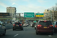
At this point, the HOV lane ends and the highway narrows to six lanes; additionally, the concrete Jersey barrier gives way to a wide, grassy median, the asphalt road surface is replaced by a concrete surface, and the expressway is no longer illuminated by streetlights, reflecting the road's location in a more rural area of Long Island.
[28] That October, the New York City Planning Commission approved a minor revision to the Queens–Midtown Expressway's route in Maspeth and South Elmhurst, thus reducing land acquisition costs by $769,000 (equivalent to $7 million in 2023[22]).
[37] The LIE was built over much of Horace Harding Boulevard within eastern Queens and Power House Road within western Nassau County.
[27] The same year, the New York State Department of Public Works later modified the highway's route in the vicinity of Little Neck Parkway, near the Queens–Nassau border, because of complaints from residents.
[42] A 1.5-mile (2.4 km) section of the LIE near Alley Pond Park in eastern Queens, between Cloverdale Boulevard in Bayside and Little Neck Parkway, officially opened on September 25, 1957.
[49][50] Between 1961 and 1963, in advance of the 1964 New York World's Fair, the NYSDOT built service roads along I-495 in Flushing Meadows–Corona Park,[53] and it constructed a partial interchange with I-678.
[54][55] Originally, I-495's westbound and eastbound roadways in Queens were separated by a median measuring three to eight feet (0.91 to 2.44 m) wide, with a chainlink fence and emergency telephones.
[59] Plans for a 90-mile (140 km) highway, the Central Motor Expressway, extending east to Riverhead in Suffolk County, Long Island, were first reported by regional newspaper Newsday in late 1953.
[62] In 1954, New York State Governor Thomas E. Dewey approved plans for the LIE, extending 64 miles (103 km) between the Queens–Nassau border and Riverhead.
[66] On September 30, 1958, the first section of the LIE outside New York City, a five-mile (8.0 km) segment from the Queens–Nassau county line to Willis Avenue in Roslyn Heights, officially opened to traffic.
[70] The New York state government awarded a construction contract for the section of the LIE between Jericho Turnpike and South Oyster Bay Road in June 1959.
[41] Real-estate developers believed that the LIE's construction was not proceeding quickly enough,[82] and Suffolk County's supervisors also advocated for the highway to be completed as soon as possible.
[81][87] A five-mile (8.0 km) extension of the LIE from Oyster Bay Road to NY 110 opened in August 1962, bringing the highway into Suffolk County.
[98] The discontinuous section of highway between William Floyd Parkway and exit 71 opened in June 1969[99][100] and was extended west to Holbrook in December 1969.
[141] Construction of the HOV lanes within Queens was delayed due to opposition from local officials and the New York City Department of Parks and Recreation.
The $55-million (equivalent to $65.7 million in 2023[22]) reconstruction included extending merge lanes, replacing and adding lighting, and improving drainage structures.
After the project was canceled in the 1970s, the west-to-northbound onramp was moved to nearby CR 3 (Pinelawn Road), and the original ramp was replaced with a park and ride.
Exit 52 (Commack Road/CR 4) was intended to be moved west to an interchange with the formerly proposed Babylon–Northport Expressway (realigned NY 231) in the vicinity of the two parking areas.
Excessive weaving between exits 52, 53, and 54 caused NYSDOT to combine all three interchanges into one and replace the west-to-southbound offramp to the Sagtikos State Parkway with a flyover ramp.
[169] Additionally in the 1970s, Suffolk County Department of Public Works proposed an extension of East Main Street in Yaphank (CR 102) that would have terminated at the west end of this interchange.
[170] In the 1960s and 1970s, the Suffolk County Planning Department considered extending CR 55 to the Grumman Calverton Naval Air Base between exits 70 and 71.
The expressway would travel east as a six-lane elevated route, 10 stories above the city streets to allow for commercial development both above and below the skyway deck.
[179][180] On December 22, 1965, TBTA announced that it had purchased a $1 million parcel of land at the northwest corner of Second Avenue and 29th Street as right-of-way that would be needed to construct the MME.
According to The New York Times, this decision was viewed as an unspoken admission by Moses that the approval could not be obtained for the proposed expressways, which included the MME.
The subway tracks would have been placed under the expressway or its service roads or in the median of a widened LIE in a similar manner to the Blue Line of the Chicago "L".