Lorca, Spain
The earliest permanent settlement is in the Guadalentín River valley, likely because of the presence of water sources, mineral resources, and the strategic positiom along a natural communication route with Andalusia.
On the hillside below the castle and the town archaeological digs have revealed the remains of an important population of the El Argar culture during the Bronze Age.
Elicroca was important enough to become a bishopric, suffragan of the primatial Metropolitan Archbishopric of Toledo, but this status would be lost under Islam.
During the Arab period it was known as Lurka and the old part of the town, made up of narrow streets and alley-ways, achieved its present shape under Moorish rule.
The city continued to grow, as in Arab times, and became the main town in an emerging rich agricultural region, although the border hindered economic development.
[11] During the late Middle Ages, Lorca was a dangerous border town, spearhead of the Christian kingdom of Murcia (belonging to the Castilian crown) against the Moorish Emirate of Granada.
The Battle of Los Alporchones, took place here in 1452, during the reign of Juan II of Castile, who ten years earlier had granted the Lorca the title of "ciudad."
[12] After the threat of war with Granada disappeared, the city changed in appearance, carrying out a series of urban reforms and developing trade.
In the seventeenth century, Lorca took shape as a modern city, but still had defensive duties due to the Ottoman threat along the coast.
Nevertheless, from 1660 a spectacular recovery and development began; amongst the construction of new buildings was the Palacio de Guevara, built in 1694 and a fine example of baroque architecture.
The 1878 edition of The Globe Encyclopaedia of Universal Information described Lorca (spelled as 'Liorca') thus: In the early twentieth century, intensive exploitation of mineral deposits of the coastal zone meant a revival of economic life in the region.
But today the flow has been reversed: the leather, pottery, cement and butcheries make the municipality an agricultural and livestock industrial tone, involving a large percentage of the population.
The twentieth century in Lorca has been a technological take-off, with slow and gradual change of social structures, the specialization of the productive sectors, etc.
[18][19] On January 29, 2005, an earthquake of 4.6 magnitude on the Richter scale with epicentre in the districts of La Paca (1,068 inhabitants in 2005) and Zarcilla de Ramos (1,077 inhabitants in 2005), caused damage especially in the structure of various buildings, and in Avilés, Coy, Doña Inés, Don Gonzalo, El Pardo, La Canaleja and Zarzadilla de Totana.
[citation needed] Lorca Castle, a fortress of medieval origin constructed between the 9th and 15th centuries suffered serious damages to its walls and the Espolón Tower during this earthquake.
It has had the following incumbents, of both the lowest (episcopal) and intermediary (archiepiscopal) ranks : The town is situated at an elevation of 370 metres (1,200 ft) in eastern Spain between Granada and Murcia.
These agricultural plains lie to the south of the main town in the valley, a strip which expands into the western part of the municipality.
There are many beaches in its 8 km (5 mi) litoral stretch of the coast line surrounded by hills with coves with sparse to dense vegetation.
Its history dates back to the Islamic period when it was built between 8th and 12th centuries; some remnants of which are still seen in the form of water systems in the older part of the castle.
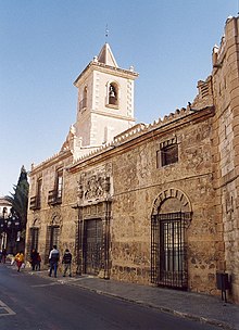
"[30] The Plaza de España (Spanish Square) is one of the most emblematic monuments of the city, located in the heart of Lorca's historical centre.
The dedication to the Irish saint, has its origins in the Battle of Los Alporchones, fought on March 17, 1452 (St. Patrick's Day) against people of the city of Granada.
The museum is a store house of all the archaeological antiquaries found during excavations in several historical areas of Lorca and from other regions in Spain.
In the lobby and the first section of the museum the exhibits are: Prehistoric Palaeolithic (95000-32000 BC) and chalcolithic period (32,000 to 9000 BC) finds seen in the flint section consist of antiquaries of scrapers, knives and points used by the hunters and gatherers who lived in Black Hill of Jofré and the Correia in Lorca; utensils arrowheads, axes, polished piece, handmade pottery, beads of people who lived in the region of Lorca during the late Neolithic period (3500 BC); the Copper Age (3000 BC) findings of funerary objects found in the caves of the hills in Lorca; stone architecture of the megaliths of the Black Hill in Lorca; the later part of the third millennium idols made from clay, bone and stone from the excavations from the Glorieta de San Vicente (Lorca city), one particular item of display is the triangular plate of stone painted in black with schematic rock art painting and other animal on the shoulder blade; the two columns of Emperor Augustus (8–7 BC) and Emperor Diocletian; and the Roman period mosaics, faces of Venus and the nine females of the period.
[30][31][32] Lorca is studded with ancient monuments built in baroque architecture, Roman villas, palaces, unique works of art.
[28] After most of the land and water supplies had been held for centuries by a minority of landowners and by Roman Catholic religious orders, Lorca began a period of sluggish economic growth during the 1960s.
Still today, its economy is largely based on agriculture and stock breeding (pigs and brown cows), although its service industries make it the commercial capital of the surrounding area.
Further advantages cited for firms to set up their establishments in Lorca are the approved plans for the allotment of land of 100,000 m2 (1,100,000 sq ft) in Hoya 800,000 m2 (8,600,000 sq ft) in Purias and the identification of land for Zarcilla de Ramos, Zarzadilla de Totana, La Paca and Almendricos for development of industries.
These costumes are finely embroidered on silk and depict historical and religious scenes; some of these cloaks are as long as 5 metres (16 ft).