Lorch am Rhein
Lorch am Rhein (German pronunciation: [ˌlɔʁç ʔam ˈʁaɪn]) is a small town in the Rheingau-Taunus-Kreis in the Regierungsbezirk of Darmstadt in Hesse, Germany.
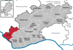
Lorch lies in the southwestern part of the Rheingau-Taunus-Kreis in the foothills of the Rheingaugebirge (range), some 10 km north of the bend in the Rhine near Rüdesheim.
The town owes its picturesque setting in the Middle Rhine Valley between Rüdesheim am Rhein and Sankt Goarshausen to its location at the mouth of the Wisper and to its steep vineyards.
The town's municipal area stretches into the richly wooded Wisper valley along Landesstraße (State Road) 3033 between Lorch and the district seat of Bad Schwalbach.
Beginning in the twelfth century, Lorch found itself at the southern end of the Rheingauer Gebück, a kind of border defence made out of an impenetrable “hedge” of stunted trees (the word itself comes from the root of the German word bücken, meaning “stoop”, a reference to the trees’ thick, low boughs).
On 10 January 1919, the Free State of Bottleneck, a provisional statelike entity between occupation zones after the First World War, was proclaimed, with Lorch as the “capital”.
The barracks in the picturesque Wisper Valley represented an important economic factor for the town of Lorch.
Meanwhile, various businesses have set up in the abandoned Bundeswehr facilities, which has offset the job losses due to the military's pullout to a certain extent.
The Rheinsteig, the new hiking trail from Wiesbaden to Bonn by way of the Ehrenbreitstein fort runs on the Rhine heights of Lorch.
After dealings with the Bundesvermögensverwaltung (“Federal Estate Administration”), the town of Lorch managed to build an industrial park with some 20 firms on the lands formerly occupied by the barracks.
The great expanse of water that is the Rhine accounts for the temperature balance, working as a reflector off which sunlight shines, thereby strengthening it.