Lothal
Lothal (Gujarati pronunciation: [lot̪ʰəl]) was one of the southernmost sites of the ancient Indus Valley civilisation,[2] located in the Bhal region of the Indian state of Gujarat.
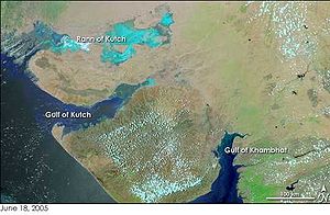
This trade route stretched between Harappan cities in Sindh (Pakistan) and the peninsula of Saurashtra where the surrounding Kutch desert of today was a part of the Arabian Sea.
However, this interpretation has been challenged by other archaeologists, who argue Khufu's Red Sea harbour at Wadi al-Jarf (Egypt) is older, dating its construction to between 2580 to 2550 BCE[4] and that Lothal was a comparatively small town, and that the "dock" was primarily an irrigation tank.
Resuming excavation in 1961, archaeologists unearthed trenches sunk on the northern, eastern and western flanks of the mound, bringing to light the inlet channels and nullah ("ravine", or "gully") connecting the dock with the river.
[11] Speculation suggests that owing to the comparatively small dimensions of the main city (7 hectares (17 acres)),[1] Lothal was not a large settlement at all, and its "dock" was perhaps an irrigation tank.
[12] However, the ASI and other contemporary archaeologists assert that the city was a part of a major river system on the trade route of the ancient peoples from Sindh to Saurashtra in Gujarat.
Small channel widths (10–300 m or 33–984 ft) when compared to the lower reaches (1.2–1.6 km or 0.75–0.99 mi) suggest the presence of a strong tidal influence upon the city—tidal waters ingressed up to and beyond the city.
The settlers lived peacefully with the Red Ware people, who adopted their lifestyle, evidenced from the flourishing trade and changing working techniques.
Harappans based around Lothal and from Sindh took this opportunity to expand their settlement and create a planned township on the lines of greater cities in the Indus valley.
The rulers of the town lived in the acropolis, which featured houses with paved bathing platforms, underground and surface drains (built of kiln-fired bricks) and potable water well.
Most of their equipment: metal tools, weights, measures, seals, earthenware and ornaments were of the uniform standard and quality found across the Indus civilization.
[citation needed] Independent businesses caved, allowing a merchant-centric system of factories to develop where hundreds of craftsmen worked for the same supplier and financier.
[22] The declining prosperity of the town, paucity of resources and poor administration increased the woes of a people pressured by consistent floods and storms.
The few people who returned to Lothal could not reconstruct and repair their city, but surprisingly continued to stay and preserved religious traditions,[citation needed] living in poorly built houses and reed huts.
[24] Hundreds of ill-equipped settlements have been attributed to this people as Late Harappans a completely de-urbanised culture characterised by rising illiteracy,[citation needed] less complex economy, unsophisticated administration and poverty.
A thick ring-like shell object found with four slits each in two margins served as a compass to measure angles on plane surfaces such as housing alignments, roads or land surveys.
Archaeologists estimate that in most cases, the bricks were in ratio 1:0.5:0.25 on three sides, in dimensions which were integral multiples of large graduations of Lothal scale of 25 mm (0.98 in).
Archaeologists have discovered gold pendants, charred ashes of terra-cotta cakes and pottery, bovine remains, beads and other signs that may indicate the practice of the Gavamayana sacrifice, associated with the ancient Vedic religion.
[34] Lothal was one of the most important centres of production for shell-working, owing to the abundance of chank shell of high quality found in the Gulf of Kutch and near the Kathiawar coast.
Cylindrical, globular and jasper beads of gold with edges at right angles resemble modern pendants used by women in Gujarat in plaits of hair.
[38] Lothal offers two new types of pottery, a convex bowl with or without stud handle and a small jar with flaring rim, both of which were found in the micaceous Red Ware period and not in contemporary Indus cultures.
The bust of a male with slit eyes, sharp nose, and square-cut beard is reminiscent of Sumerian figures, especially stone sculptures from Mari.
Erosion and brick robbery are responsible for the absence of high standing walls as well as the ancient nullah, inlet channel, and riverbed.
[19] The ASI has covered the peripheral walls, the wharf, and many houses of the early phase with earth to protect from natural phenomena, but the entire archaeological site is nevertheless facing grave concerns about necessary preservation.
Officials blame the salinity on capillary action and point out that cracks are emerging and foundations weakening even as restoration work slowly progresses.
[45] The trapezoidal, burn brick, structure is located on the east of the town and away from the main river channel, to possibly avoid deposition of silt.
[48] Rao's identification of basin as a dock was challenged by Leshnik in 1968 and later Yule in 1982,[49][12] who offered an alternative assessment of the feature as primarily an irrigation tank.
The identification of just two wells in the town, one on the southern edge of the dock and the other on the acropolis, were also offered to support the alternative primary purpose, as a tank to irrigate vegetables in the adjoining fields, a place to bathe, and a quay to unload river boats.
This knowledge also enabled them to select Lothal's location in the first place, as the Gulf of Khambhat has the highest tidal amplitude and ships can be sluiced through flow tides in the river estuary.
[citation needed] However, with rising prosperity, Lothal's people failed to upkeep their walls and dock facilities, possibly as a result of over-confidence in their systems.