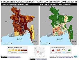
Low Elevation Coastal Zone
[4] The term Low Elevation Coastal Zone was defined as "the contiguous area along the coast that is less than 10 metres above sea level" in a 2007 paper by McGranahan et al.,[5] although since then various elevation thresholds such as 5 meters have been used to define the LECZ for research purposes.
It represents the population in a region that may be vulnerable to impacts of present and future flooding and sea level rise.
[4] The Low Elevation Coastal Zone has been estimated and mapped for the globe as well as for many countries, territories, and cities by the Socioeconomic Data and Applications Center at Columbia University as part of NASA's Earth Observing System Data and Information System (see maps here) as well as by researchers.
The Intergovernmental Panel on Climate Change's Special Report on the Ocean and Cryosphere in a Changing Climate includes a figure (Figure CB9.1) that is a global map of low-lying islands and coasts, including the LECZ and low-lying islands.
[6] The global population living in the Low Elevation Coastal Zone is substantial and growing.