Lowther Castle Stead
In the Middle Ages, before the woodland was established, the castle's visibility would have made it a significant landmark in the area.
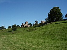
[2] The castle is 330 metres (360 yd) south of the Church of St Michael which, which dates to at least the late 12th century.
[8] Around this time, a pele tower was established about 400 metres (1,300 ft) south-east of the ringwork castle.
This developed into a country house, and from the 19th century took on the name of Lowther Castle; it was abandoned after World war II.
[4] In 1997, Lancaster University Archaeology Unit carried out a survey of the earthworks of the castle and associated medieval village to the east and north.
[13] Lowther Castle consists of a roughly square enclosure bounded by a bank.