M-5 (Michigan highway)
It starts in Commerce Township as a north–south divided highway and freeway called the Haggerty Connector and connects with Interstate 96 (I-96) in Novi.
The trunkline passes between suburban residential subdivisions and along urban commercial areas while serving 17,200–68,800 vehicles on average each day.
Grand River Avenue started as the path of an early wagon trail in the Michigan Territory, carrying settlers from Detroit inland along a route previously used by Native Americans.
Grand River Avenue was supposed to be the path for I-96 from Novi into downtown Detroit, and a section of freeway now used by M-5 was constructed as part of I-96 before the Interstate was rerouted to a different location.
South of Maple Road, the highway is bordered by commercial developments to the east and Long Park to the west as it angles southeasterly.
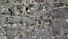
Immediately south of the 13 Mile Road intersection, M-5's median widens out as the highway transitions to a full freeway called the Haggerty Connector.
Through this interchange complex that straddles the Novi–Farmington Hills city line, M-5 turns to the southeast, and signage changes direction.
Once again running through suburban Farmington Hills, the trunkline passes Botsford Hospital before intersecting 8 Mile Road.
This intersection marks the place where M-5 crosses into Wayne County, and the western terminus of the M-102 designation on 8 Mile Road.
Grand River Avenue runs through the northern section of Redford Township in Wayne County and crosses into Detroit at the intersection with 7 Mile Road and 5 Points Street.
The properties bordering M-5 transition to commercial use past these two green spaces, and the highway continues southeasterly through the city as an undivided street.
M-5 crosses over M-39 (Southfield Freeway) near the intersection with Fenkell Street,[4][5] which would be 5 Mile Road in the Detroit grid system.
Although a few sources still indicate M-5 ending at the interchange with I-96 between Schoolcraft and Plymouth roads in the middle of another larger commercial zone;[4][5] M-5 continues past this location along a portion of Grand River Avenue that until April–May 2016 was part of unsigned highway Old BS I-96.
In the North Corktown neighborhood, Grand River Avenue crosses M-10 (Lodge Freeway) near the MotorCity Casino.
About a half mile (0.7 km) past M-10, M-5 crosses I-75 (Fisher Freeway) and enters Downtown Detroit's Foxtown neighborhood.
[8] All of M-5 has been listed on the National Highway System,[9] a network of roads important to the country's economy, defense, and mobility.
[5] Starting in 1933, M-5 was used as the designation along a section of highway that was previously part of US 2 in Mackinac and Chippewa counties in the Upper Peninsula.
[16] A ten-year project to construct a plank road between Detroit and Howell was authorized in 1820 along the Grand River Trail.
[18] The opening of the Erie Canal in New York in 1826 brought new settlers to the Great Lakes region, and to the future state of Michigan.
[29] The General Location of National System of Interstate Highways Including All Additional Routes at Urban Areas Designated in September 1955, or Yellow Book after the cover color, showed generalized plans for the locations of Interstate Highways as designated in 1955.
New signage for M-10 exit 2C (serving Grand River Avenue) installed in 2018 included M-5 trailblazers, further cementing this extension.
A freeway running north of Novi to the Davisburg area was included in the original Interstate Highway plans for Michigan.
This last project also included a northern extension of roadway into the Eldorado Golf Course in Commerce Township to better serve the community.