M8 motorway (Scotland)
[1] It connects the country's two largest cities, Glasgow and Edinburgh, and serves other large communities including Airdrie, Coatbridge, Greenock, Livingston and Paisley.
With the advent of motorway-building in the United Kingdom in the late 1950s, the M8 was planned as one of a core of new motorways, designed to replace the A8 road as a high-capacity alternative for intercity travel.
The central section – the uncompleted Glasgow Inner Ring Road – contains numerous junctions serving local communities including Cowcaddens, Garnethill, Kelvingrove and Anderston.
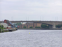
It then crosses the River Clyde on the Kingston Bridge, runs west through Kinning Park, Bellahouston and Hillington before leaving Glasgow.
This section is mainly elevated on a concrete viaduct, lowering pollution concentrations but exposing some public spaces, roof terraces and other parts of buildings to noise and shading.
Prior to the construction of the M74 extension, attempts were made to minimise delays on this section; these included restricting exits around the Kingston Bridge, a ramp metering programme, and expanded use of electronic signing above and beside the motorway as part of the CITRAC (Centrally Integrated TRAffic Control) system.
[14] Successive failed attempts were made to build the southern flank of the Glasgow Inner Ring Road envisaged by the Bruce Report of the late 1940s.