Green Line (MBTA)
The line was assigned the green color in 1967 during a systemwide rebranding because several branches pass through sections of the Emerald Necklace of Boston.
[7][8][9] The four branches are the remnants of a large streetcar system, which began in 1856 with the Cambridge Horse Railroad and was consolidated into the Boston Elevated Railway several decades later.
Rolling stock as of June 2024[update]:[2][12] Only MBTA operated vehicles are included here, not cars from the Boston Elevated Railway era.
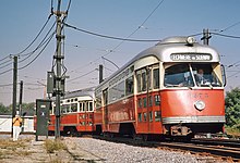
[14] Two older streetcars are on display on the unused outer inbound track at Boylston station, which formerly carried cars coming from the Pleasant Street portal.
[15] In 1971, as part of a program to supply further work to defense contractors as the Vietnam War wound down, the Urban Mass Transit Administration selected Boeing Vertol as systems manager for a project to design a new generic light rail vehicle.
[18] Desperate for reliable rolling stock, in 1977 MBTA launched an overhaul program to extend the availability of its older PCC cars.
The agency was also forced to spend an additional US$9.5 million to modify tracks to prevent derailments and the Type 8 fleet was unable to be used on the D branch (where cars reach full speed) after those modifications were complete in 2008.
[26] Of the remaining cars, six were sold to the US Government and are now in Pueblo, Colorado for testing purposes, one was given to the Seashore Trolley Museum, and three were retained by the MBTA for work service.
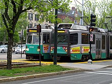
The Type 9 cars will provide additional rolling stock to allow for Green Line Extension operations, and will not replace any of the existing fleet.
In June 2021, the MBTA indicated that the initial order would be for 102 LRVs operating as single cars, with two-car trains deferred for a later project with federal funding.
To address this issue and comply with changing federal and state laws, additional facilities have been added:[40] Beginning in the 1850s, Boston sprouted a large network of horsecar lines, the first public transit in the city.
It used modified existing horsecars outfitted with Frank J. Sprague's revolutionary electrical equipment, which had first been demonstrated the previous year in Richmond, Virginia.
Beginning in the 1930s, the massive surface streetcar system was "bustituted" with buses and trackless trolleys which had lower operating costs and more flexible routes.
In 1959, the Boston and Albany Railroad's Highland Branch was converted to the Riverside Line, a fully grade-separated suburban service.
The new agency was unpopular, even spawning a popular protest song; in 1964, it was replaced with the Massachusetts Bay Transportation Authority which had an expanded funding area to preserve suburban commuter rail lines.
In 2001, with new low-floor streetcars entering service, the MBTA began retrofitting underground stations and major surface stops with low raised platforms for accessibility for all.
Interlockings are controlled through a wayside Automatic Vehicle Identification (AVI) system that relies on the operator properly entering the destination manually on a roto-wheel in the train cab at the beginning of a run.
Signs in most station on those lines began to display real-time train information in late 2012 and early 2013, while data feeds have been available for smartphone applications since 2010.
In January 2013, the MBTA announced plans to provide full tracking data for the Green Line by 2015, allowing use of smartphone applications and in-station countdown signs.
The Union Square Branch runs 0.7 miles (1.1 km) west from Red Bridge, sharing the Fitchburg Line right of way.
A new vehicle storage yard and maintenance facility is located in the Inner Belt area, with leads from both branches at Red Bridge.
To settle a lawsuit with the Conservation Law Foundation to mitigate increased automobile emissions from the Big Dig, the Commonwealth of Massachusetts agreed in 1990 to extend the Green Line from Lechmere to Medford Hillside through Somerville and Medford, two suburbs underserved by the MBTA relative to their population densities, commercial importance, and proximity to Boston.
The majority of the Green Line opened by 1959, long before the 1990 Americans with Disabilities Act mandated that new construction be fully accessible.
[78] Construction of raised platforms was completed at Park Street and Haymarket around 2003; Prudential was also reconstructed that year by the developer of 111 Huntington Avenue.
[7] Wooden mini-high platforms, allowing level boarding on older Type 7 LRVs, were installed at eight Green Line stations in 2006–07 as part of the settlement of Joanne Daniels-Finegold, et al. v.
[86] Several other surface accessibility projects are planned: This listing includes only the Green Line section between Lechmere and Kenmore, which are served by multiple branches.
[95] On October 8, 2012, two E branch trolleys collided in the 700 block of Huntington Avenue near Brigham Circle when one derailed into the other, injuring three people including a train operator.
The number of incidents had been increasing for several years due to deferred maintenance on tracks and wheels, which resulted in more low-speed derailments of Type 8 cars.
The National Transportation Safety Board, Federal Transit Administration, and Massachusetts Department of Public Utilities are investigating the derailment.
[106] In 2009, the National Transportation Safety Board recommended that the Green Line be outfitted with positive train control to prevent collisions as part of its various crash investigations.