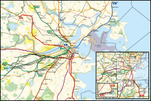
MBTA subway
The five branches of the Silver Line bus network are also shown as part of the rapid transit system.
Opened in September 1897, the four-track-wide segment of the Green Line tunnel between Park Street and Boylston stations was the first subway in the United States, and has been designated a National Historic Landmark.
Streetcar congestion in downtown Boston led to the creation of underground subways and elevated rail, the former in 1897 and the latter in 1901.
[4] The grade-separated railways added transportation capacity while avoiding delays caused by intersections with cross streets.
The last elevated heavy rail or "El" inter-station segments in Boston – with the exception of the Red Line's still-active elevated tracks, connecting Charles/MGH station over Charles Circle to the Longfellow Bridge and the Cambridge Tunnel's northern portal – were at the extremities of the Orange Line: its northern end was relocated in 1975 from Everett to Malden, MA, and its southern end was relocated into the Southwest Corridor in 1987.
However, the Green Line's Causeway Street Elevated remained in service until 2004, when it was relocated into a tunnel with an incline to reconnect to the Lechmere Viaduct.
[7] Originally, transit lines in the region only used geographic names; though numbering was added to public maps in 1936.
[8] Colors were assigned on August 26, 1965, as part of a wider modernization under design standards developed by Cambridge Seven Associates, and have served as the primary identifier for the lines since then.
[10] When sketching design concepts, Peter Chermayeff labeled the subway-surface light rail routes as the Green Line because they run adjacent to parts of the Emerald Necklace park system.
Green Line Extension stations require proof of payment verification at a fare machine.

