Mackenzie River
The river's main stem is 1,738 kilometres (1,080 mi) long, flowing north-northwest from Great Slave Lake into the Arctic Ocean, where it forms a large delta at its mouth.
The Mackenzie valley is believed to have been the path taken by prehistoric peoples during the initial human migration from Asia to North America over 10,000 years ago, despite sparse evidence.
Together, the Peace and Athabasca rivers drain a significant portion of the eastern slope of the Rocky Mountains and the central Alberta prairie.
The channel is initially several kilometres wide but narrows to about 800 metres (2,600 ft) at Fort Providence, which was historically an important ferry crossing in the summer, and used as an ice bridge in the winter for traffic along the Yellowknife Highway.
[20] After heading west for about 100 kilometres (62 mi) the Mackenzie narrows and turns northwest through a long stretch of fast water and rapids, past the village of Jean Marie River.
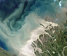
The Liard drains a large area in the southern Yukon and northern BC and carries a large amount of sediment during the summer melt[21] — which does not fully mix with the clear water in the Mackenzie for almost 500 kilometres (310 mi) downstream, with the resulting phenomenon of a clear current on the east bank and muddy water on the west bank.
It flows through open taiga with its wide valley bounded, on the west, by the Mackenzie Mountains and to the east by low hills of the Canadian Shield.
The Mackenzie here flows slightly lower in elevation than the surrounding tundra, as a braided river between low bluffs about 3 to 5 kilometres (1.9 to 3.1 mi) apart.
[30] Lowland divides in the north separate the Mackenzie basin from the Arctic Ocean watersheds of the Anderson, Horton, Coppermine and Back Rivers.
The eastern portion of the Mackenzie basin is dominated by vast reaches of lake-studded boreal forest and includes many of the largest lakes in North America.
[32][33] The river is frozen for most of the year, with the ice typically breaking up by early to mid-May in the south, and late May-early June in the north.
Year round, the Mackenzie's outflow has a major stabilizing effect in the local climate above the Arctic Ocean with large amounts of warmer fresh water mixing with the cold seawater.
[40] Mackenzie monthly mean discharge at Arctic Red River (m3/s)[40] As recently as the last glacial maximum about 30,000 years ago, the majority of northern Canada was buried under the enormous continental Laurentide Ice Sheet.
[31][41] Today's Mackenzie River is very young in geologic terms – its channel formed over a period of no more than several thousand years as the ice sheet retreated.
In the north, the river's shores are lined with sparse vegetation like dwarf birch and willows, as well as extensive areas of muskeg and peat bogs.
South of Great Slave Lake, there are much larger reaches of temperate and alpine forest, prairie, and fertile floodplain and riparian habitat.
Bennett Dam on the Peace River has reduced the seasonal variations of water levels in the delta, causing damage to its ecosystem.
[52] The Mackenzie valley is believed to have been the path taken by prehistoric peoples during the initial human migration from Asia to North America more than 10,000 years ago.
[56] Steamboat service on the Mackenzie River began in the 1880s, and the number of vessels surged in the early 1900s as the Klondike Gold Rush brought a wave of prospectors to the Yukon.
This demand grew when gold was discovered on the northern shore of Great Slave Lake, leading to the settlement of Yellowknife and the opening of several mines in the area.
[58] In 1964 the Mackenzie Northern Railway (now a subsidiary of CN) reached the shore of Great Slave Lake, to serve the new Pine Point zinc mine near Hay River.
[61] In 2008, Canadian and Japanese researchers extracted a constant stream of natural gas from a test project at the Mallik methane hydrate field in the Mackenzie Delta.
[64] Some parts of the Mackenzie basin are rich in natural resources – oil and gas in the Northwest Territories and in central Alberta, lumber in the Peace River headwaters, uranium in Saskatchewan, gold and zinc in the Great Slave Lake area and tungsten in the Yukon.
[65][66] According to the British Columbia Environmental Network, "there is enough agricultural capability in the Peace River Valley to provide vegetables to all of northern Canada".
Barge traffic travels the entire length of the Mackenzie in long "trains" of up to fifteen shallow-draft vessels pulled by tugboats.
Goods are shipped as far as the port of Tuktoyaktuk on the eastern end of the Mackenzie Delta, where they are transferred to oceangoing vessels and delivered to communities along Canada's Arctic coast and the numerous islands to the north.
[71] In winter, the frozen channel of the Mackenzie River, especially in the delta region, is used as an ice road, firm enough to support large trucks, although travel between northern communities is mostly by dog sleds and snowmobiles.
[76] Other smaller hydroelectric plants are located along the Snare and Taltson River tributaries, providing power to mines in the Great Slave Lake region.
A potential US$1 billion, 1350 MW hydro plant on the Slave River was canceled in 2010 after an agreement could not be reached with First Nations people in the area to be flooded by the reservoir.
[67][83] As of April 2019, despite multiple legal challenges by First Nations and environmental groups the dam was under construction, with a completion date scheduled for 2024.