Beaufort Sea
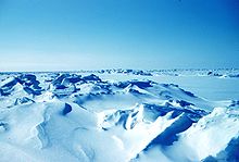
Historically, only a narrow pass up to 100 km (62 mi) opened in August–September near its shores, but recently due to climate change in the Arctic the ice-free area in late summer has greatly enlarged.
[8] In April 2011, the Canadian government signed a memorandum of understanding with the Inuvialuit as a first step in developing a larger ocean management plan.
[9] The Canadian government announced in October 2014 that no new commercial fisheries in the Beaufort Sea will be considered until research has shown sustainable stocks that would be made available to Inuvialuit first.
There is an unresolved dispute involving a wedge-shaped slice on the International Boundary in the Beaufort Sea, between the Canadian territory of Yukon and the U.S. state of Alaska.
Canada claims the maritime boundary to be along the 141st meridian west out to a distance of 200 nmi (370 km; 230 mi), following the Alaska–Yukon land border.
Canada is the successor state to Great Britain in relation to this treaty, which stipulates:[16] the line of demarcation shall follow the summit of the mountains situated parallel to the Coast, as far as the point of intersection of the 141st degree of West longitude […] and, finally, from the said point of intersection, the said Meridian Line of the 141st degree, in its prolongation as far as the Frozen OceanCanada maintains that this treaty is extensible from the land into the Beaufort Sea along the meridian.
[19] (In that latter dispute, both of those arguments were rejected, and the border was drawn based upon geometric principles taking into account geographic factors.
[19]) Neither the U.S. nor Canada has pressed for a swift resolution for the matter, or arbitration at the International Court of Justice, however;[16] and the two have in the meantime cooperated in several measures aimed at preserving the maritime environment.
[16][19] Before the end of 2004, the US leased eight plots of land below the water for oil exploration and exploitation, provoking a diplomatic protest from Canada.
[22] On 20 August 2009, United States Secretary of Commerce Gary Locke announced a moratorium on commercial fishing of the Beaufort Sea north of Alaska, including the disputed waters.
[needs update] A joint geological survey of the area has been initiated, and the issue was marked as settled by the CIA World Factbook,[25] though no official document has been released by September 2010.
On August 20, 2009 United States Secretary of Commerce Gary Locke announced a moratorium on fishing the Beaufort Sea north of Alaska.
[24] Randy Boswell, of Canada.com wrote that the disputed area covered a 21,436 square kilometres (8,276 sq mi) section of the Beaufort Sea.
Jack Layton, leader of the New Democratic Party of Canada, called the U.S. moratorium over the disputed waters in the Beaufort Sea the "largest encroachment on Canadian territory in our history.
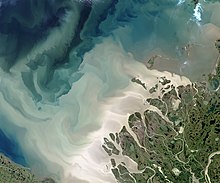
The coastal shelf area is rather narrow, especially near and east of Point Barrow in the Alaskan part of the sea, and contains numerous submarine valleys.
Near the coast, the depths are shallower than 60 m (200 ft) but they rapidly increase northwards up to a few kilometers, transforming into a massive platform which is geologically similar to that of the oceans.
[3] The soil is frozen all year around at the depth below about 1 m (3 ft 3 in) or less, forming permafrost, and only the top few tens of centimeters thaws in summer.
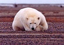
[3] The shoreline of the Beaufort Sea is covered with tundra and marks the northern limit of the terrestrial range[citation needed] of the polar bear in North America.
[citation needed] Belugas spend summer in the coastal area and Mackenzie River delta, which are free of ice then, and in winter migrate long distances to the polynyas of the deep sea.
[citation needed] Genetic analyses have confirmed that belugas of the Beaufort Sea are clearly distinct from those of other Canadian and Alaskan waters, despite often sharing a common wintering habitat.
On top of the food pyramid stands the polar bear, which feeds primarily on seals, but also on any large marine mammals when it has a chance, such as carcasses and whales trapped in ice fields.
[41] "There is only one proposed Early-Entry site in eastern Beringia that still has proponents, Bluefish Caves in the Porcupine River Basin, Yukon Territory, Canada.
When redated using accelerator mass spectrometry (AMS) of small amounts of remnant collagen the bone produced a 1.8 kya date (Yesner 1996b:255)".
[3] Trapping of muskrat at the Mackenzie River delta was the main source of income for the Athabaskan First Nations peoples and Inuit during 1920–1960, but has since declined.
[46] These activities resulted in dredging of about 46.5 million m3 of sea bottom soil, as well as discharge of drilling muds which contained barite, clay, caustic soda, and heavy metals zinc, copper, lead, chromium, cobalt, nickel, cadmium and mercury.
This problem was alleviated for Prudhoe Bay by constructing the Trans-Alaska Pipeline, but is limiting regular commercial production at Mackenzie River deposits.