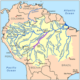
Madeira River
The waters flow into the Madeira from many large rivers, the principal of which, (from east to west), are the Guaporé or Iténez, the Baures and Blanco, the Itonamas or San Miguel, the Mamoré, Beni, and Madre de Dios or Mayutata, all of which are reinforced by numerous secondary but powerful affluents.
All of the upper branches of the river Madeira find their way to the falls across the open, almost level Mojos and Beni plains, 90,000 km2 (35,000 sq mi) of which are yearly flooded to an average depth of about one meter (3 ft) for a period of from three to four months.
Below Porto Velho the Madeira meanders north-eastward through the Rondônia and Amazonas states of north west Brazil to its junction with the Amazon.
The 283,117 hectares (2,800 km2; 1,100 sq mi) Rio Madeira Sustainable Development Reserve, created in 2006, extends along the north bank of the river opposite the town of Novo Aripuanã.
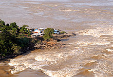
The Madeira river rises more than 15 m (50 ft) during the rainy season, and ocean vessels may ascend it to the Falls of San Antonio, near Porto Velho, Brazil, 1,070 km (660 mi) above its mouth; but in the dry months, from June to November, it is only navigable for the same distance for craft drawing about 2 meters (7 ft) of water.
The Madeira-Mamoré Railroad runs in a 365 km (227 mi) loop around the unnavigable section to Guajará-Mirim on the Mamoré River, but is not functional, limiting shipping from the Atlantic at Porto Velho.
The dam projects include large ship-locks capable of moving oceangoing vessels between the impounded reservoir and the downstream river.
If the project is completed, "more than 4,000 km [2,500 mi] of waterways upstream from the dams in Brazil, Bolivia, and Peru would become navigable.
[18][19] The Worldwatch institute has also criticized the fast-track approval process for "kindler, gentler dams with smaller reservoirs, designed to lessen social and environmental impacts", claiming that no project should "fast-track the licensing of new dams in Amazonia and allow projects to circumvent Brazil's tough environmental laws".