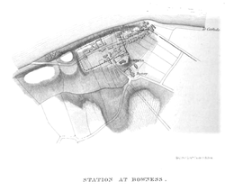
Mais (Bowness)
[5] The fort stood on a sea-cliff over 50 feet (15 m) high, rising steeply from the shore, and commanding lower ground in all directions.
The name 'Bowness' means 'rounded headland', indicating the good position of the fort, having commanding views of the nearby coastline.
Old inhabitants reported that, 250 yards (230 m) west of the fort a large quantity of stone was dug out of the beach.
Over the years the cliff face has been eroded, and the north wall of the fort collapsed into the sea long ago.
In 1973 more extensive excavations were carried out, and traces of the original turf and clay western rampart were found, as well as evidence of a timber gate-tower.