Majorcan cartographic school
This coincided with a period of Aragonese expansionism across the Mediterranean to Sardinia and Corsica, Sicily and Greece (Athens and Neopatria), in which Majorcan nautical, cartographic and mercantile expertise was often called upon.
Majorcan merchants and seafarers spearheaded the attempt by the Aragonese crown to seize the newly discovered Canary Islands in the Atlantic from the 1340s to the 1360s.
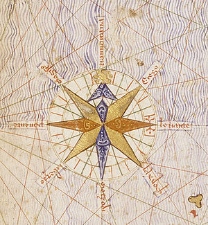
The portolan was a realistic, detailed nautical chart, gridded by a rhumbline network with compass lines that could be used to deduce exact sailing directions between any two points.
Unlike the circular mappa mundi of Christian academic tradition, the portolan was oriented towards the north, and focused on a realistic depiction of geographic distances with a degree of accuracy that is astounding, even by modern standards.
Nordenskiöld, that the surviving charts are misleading, that the earliest Genoese maps were just faithful copies of a conjectured prototype, now lost, composed around 1300 by an unknown Majorcan cosmographer, possibly with the involvement of Ramon Llull.
[4] Recent research tends to lean towards the first interpretation, but at the same time curbing some of the more extreme Italian claims and recognizing distinctively Majorcan development.
Both Italian and Majorcan portolan charts focus on the same geographic area, what is sometimes called the "Normal Portolan": the Mediterranean Sea, the Black Sea and the Atlantic Ocean coast up to the environs of Flanders - the area frequently travelled by contemporary Mediterranean merchants and sailors.
As time and knowledge progressed, some cartographers stretched the geographic boundaries of the normal portolan to include a larger swathe of Atlantic ocean, including many Atlantic islands, real and mythical, a longer stretch of the west African coast to the south, the Baltic Sea in the north and the Caspian Sea in the east.
The Majorcan style, its beginnings already decipherable in the 1339 chart of Angelino Dulcert, and finding its epitome in the Catalan Atlas of 1375, attributed to Majorcan cartographer Abraham Cresques, contained a lot more inland detail and was replete with rich colorful illustrations, depicting cities, mountain ranges, rivers and some miniature people.
As a result, the school suffered heavily and eventually expired with the extension of force-conversion, expulsions and the Spanish Inquisition into the realms of the Crown of Aragon in the late 15th century.
Muslim and Jewish merchants participated in extensive trade with Egypt and Tunisia, and in the 14th century they started doing business with England and Netherlands.
Professor Gerald Crone, who wrote books on medieval mapping, said of these cartographers, they "...threw off the bounds of tradition and anticipated the achievements of the Renaissance".
The maps made in Majorca were easy to recognize by their brightly colored illustrations of significant geographical features and portraits of foreign rulers.
Dulcert made precise, colorful drawings that showed all the topographical details including rivers, lakes, mountains, etc.
John I of Aragon advised the authorities that he needed to get a map, which would show the Strait of Gibraltar, the Atlantic coast and the ocean itself.
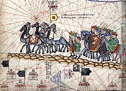
[10][11] The first two leaves, forming the oriental portion of the Catalan Atlas, illustrate numerous religious references as well as a synthesis of medieval mappae mundi (Jerusalem located close to the center) and the travel literature of the time, notably Marco Polo's Book of Marvels and the Travels, and Voyage of Sir John Mandeville.
"[8][12]While the areas under Muslim control were marked with domes, Jerusalem was surrounded by tales from Old and New Testaments like the Garden of Eden, the crucifixion, Noah's Ark and others.
The image of the caravan is accompanied by Marco Polo's travel account: You must know that those who wish to cross this desert remain and lodge for one whole week in a town named Lop, where they and their beasts can rest.