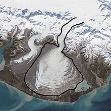
Malaspina Glacier
The colonial name for the glacier is in honor of Alessandro Malaspina, a Tuscan explorer in the service of the Spanish Navy, who visited the region in 1791.
In 1874, W. H. Dall of the United States Coast Survey bestowed the name "Malaspina Plateau" on it, not realizing its true geological character.
Nearly all of the glacier is encompassed by the southeast lobe of the Wrangell-St. Elias National Park and Preserve.
Radar data and aerial photographs dating back to 1972 provide evidence that the Malaspina-Seward glacier system lost about 20 m (66 ft) of its thickness between 1980 and 2000; because the glacier is so large, that amount of shrinkage was sufficient to contribute 0.5% of the rise in the global sea level.
[5] In October 1969, the glacier became a National Natural Landmark.