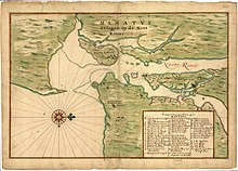
Manatus Map
Entitled Manatvs gelegen op de Noort Rivier (Manhattan situated on the North River) it shows the geographic features of the region, as well as New Amsterdam and other New Netherland settlements.
[2] Isaac Newton Phelps Stokes did not exclude any of several candidates except for Andries Hudde, due to travel back to Europe for his marriage in that year.
[3] The original drawing is lost and It survives only in two later 17th-century copies made in the same studio with slight differences, as noted in Stokes' The Iconography of Manhattan Island.
Depicted in Manhattan situated on the North Rivier and explained in a numbered key to the main places in an inset are the properties of the company (Dutch: Westindische Compagnie or WIC) and early New Netherlanders.
[2] Some were bouweries, or homesteads which included dwellings and out buildings, and others were plantages, or plantations, sometimes worked by company slaves.