Manchester Bolton & Bury Canal
Most of the freight carried was coal from local collieries but, as the mines reached the end of their working lives sections of the canal fell into disuse and disrepair and it was officially abandoned in 1961.
Financial unrest and British involvement in the American Revolutionary War restricted local transport investment to road improvements.
[4] With the arrival of more favourable conditions, including the end of the war, a proposal for a canal to link the towns of Manchester, Bolton and Bury was mooted.
Matthew Fletcher had in 1789 been employed as a technical advisor and had surveyed the route of the proposed canal,[5] but the first public notice came from Manchester on 4 September 1790.
[7] A meeting was "intended to be holden at the House of Mr Shawe, the Bull's Head in Manchester aforesaid, on Monday, the twentieth day of this instant, September, at eleven o'clock in the forenoon", where "Surveys, Plans, Levels, Estimates and Proposals" would be presented.
[6][8] A further meeting on 16 September, held in Bolton, appointed a committee of six Boltonians chaired by Lord Grey de Wilton to attend at Manchester.
A series of resolutions at this meeting followed a discussion of the route, and authorised the necessary actions to bring the plan into fruition, which included the petitioning of Parliament for the required bill.
[6] A meeting in Bury at the Eagle & Child public house on 29 September 1790 secured an agreement that "the utility of this scheme nevertheless cannot with propriety be ascertained until such time as it has been certified, from whence and in what proportion the proprietors of the intended navigation expect to draw their resources of water".
[9] At another meeting in Bury, on 13 October 1790, Hugh Henshall gave a written report on the canal, and stated that his plan would not require water from the river in times of drought, but that floods and rivulets would supply his reservoirs.
[11] A document entitled "A list of subscribers to the intended Bolton Bury and Manchester Canal Navigation", now kept in the Greater Manchester County Record Office,[12] lists notable subscribers including the Earl of Derby, Lord Grey de Wilton, Matthew Fletcher, and Robert Peel.
3. c. 68), for the construction of the canal, by which "the proprietors were empowered to purchase land for a breadth of 26 yards on level ground, and wider where required for cuttings or embankments.
Matthew Fletcher was ordered to meet with land owners to discuss the purchase of any land along the route of the canal, and with this in mind, on 30 July 1791 John Seddon of Sandy Lane was ordered to survey the line of the canal beginning within the estate of John Edenson Heathcote, and ending at the southern extremity of the Reverend Dauntesey's estate.
A 5.75-mile (9.25 km) length between Oldfield Lane in Salford and Giants Seat Locks in Outwood was navigable with 3 feet 8 inches (1.12 m) of water.
The stretch to Bolton had at this time been widened, with several bridges requiring further work, incomplete embankments, construction of a weir, and gravelling of the towpath.
One proposed remedy involved the construction of an aqueduct over the River Irwell in Manchester, to connect directly to the Rochdale Canal between Castlefield and Piccadilly.
Food and drink was made available to those using the canal in several places including Margaret Barlow's Tea Gardens, Kilcoby Cottage and Rhodes Lock.
[49] Passengers would change boats at Prestolee to avoid delays at the lock flight and also to save water,[17] and a purpose-built covered walkway the length of the road was constructed for their benefit.
Alexander Nimmo was employed to report on the proposal and told that it was possible "so far as he expressed himself capable of judging from his present cursory view of the canal".
[59] The canal therefore survived, although locks 4 and 5 in Salford were moved and combined into a two-rise staircase, with a second tunnel built underneath the line[60][61] which became known as the Manchester and Bolton Railway.
10.45 acres (42,300 m2) of land around this breach was purchased from the British Transport Commission by Cream's Paper Mill, who subsequently built over part of the canal.
[67] The proposal was not carried[68] but four years later, under the London, Midland and Scottish Railway Act of 1941, they abandoned 7 miles (11 km) of the canal, including a section from Prestolee to Clifton and the entire Bolton arm.
[72] A British Transport Commission report of 1955 included the canal in its list of "Waterways having insufficient commercial prospects to justify their retention for navigation".
One of the earliest surviving cranes in England, it was built some time about 1875–1884 for Mount Sion Bleach Works by Thomas Smith & Sons of Rodley and was used to unload coal boxes from barges into the yard below the canal.
The design changes to the canal were not completely without merit, since they allowed two narrowboats to use each lock simultaneously, saving passage time and water.
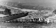
As early as 1799 a flood carried away large sections of the lower banks,[30] and on 15 October 1853 two boats were swept through a 93-yard (85 m) breach near the bottom of Nob End Locks (no injuries were reported).
[90] One of the most serious breaches occurred on 6 July 1936 near Nob End, close to the junction of the canal's three arms, reported by the Manchester Evening News the following day.
Mr John W. Martin, of Loxham Street, Bolton, said: "I was cycling along the bank when I suddenly saw signs of a subsidence begin on a bend in the canal.
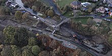
The route of St Peter's Way has almost entirely destroyed a significant section of the canal as it heads into the centre of Bolton[95] and Church Wharf no longer exists.
Restoration was halted briefly by the discovery of what was initially thought to be a Second World War bomb[100] but which proved to be a wartime American mortar with no explosive content.
Completion was scheduled for the end of July 2008[103] and marked with an opening ceremony on 19 September that year, during which the new Margaret Fletcher tunnel under the Manchester Inner Ring Road was formally named.