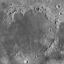
Mare Imbrium
The Imbrium Basin is surrounded by three concentric rings of mountains, uplifted by the colossal impact event that excavated it.
[6] The ring mountains are not as well developed to the north and west, and it appears they were simply not raised as high in these regions by the Imbrium impact.
It is thought that the original crater left by the Imbrium impact was as much as 100 km deep, but that the floor of the basin bounced back upwards immediately afterwards.
Surrounding the Imbrium Basin is a region blanketed by ejecta from the impact, extending roughly 800 km outward.
A mass concentration (mascon), or gravitational high, was identified in the center of Mare Imbrium from Doppler tracking of the five Lunar Orbiter spacecraft in 1968.
Ewen A. Whitaker argues that this likely refers to Mare Imbrium, "the largest regular-shaped dark area unbroken by bright patches" that can be seen with the naked eye.
[12] Around 1600, William Gilbert made a map of the Moon that names Mare Imbrium "Regio Magna Orientalis" (the Large Eastern Region).
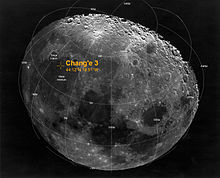
In 1971, the crewed Apollo 15 mission landed in the southeastern region of Mare Imbrium, between Hadley Rille and the Apennine Mountains.
Command Module Pilot Alfred Worden remained in orbit and acquired hundreds of high-resolution photographs of Mare Imbrium (and other regions of the Moon) as well as other types of scientific data.
Samples were collected from Mons Hadley Delta, believed to be a fault block of pre-Imbrian (Nectarian or Pre-Nectarian) lunar crust, including the "Genesis Rock."