County of Flanders
The County of Flanders[b] was one of the most powerful political entities in the medieval Low Countries, located on the North Sea coast of modern-day Belgium and north-eastern France.
For centuries, the economic activity of the Flemish cities, such as Ghent, Bruges and Ypres, made Flanders one of the most affluent regions in Europe, and also gave them strong international connections to trading partners.
Aside from this, the counts, from the 11th century onward, held land east of the river as a fief of the Holy Roman Empire, and this is referred to as "Imperial Flanders" (Rijks-Vlaanderen or Flandre impériale).
From 1384, the county was politically united to the Duchy of Burgundy, and it formed the starting point for more acquisitions in the area, and the eventual creation of the Burgundian Netherlands.
The expansion of Flemish ("Burgundian") power deep into the Holy Roman Empire further complicated the relationship between Flanders and France, but reinforced the connections with Brabant, Hainaut, Holland and other parts of the Low Countries.
A Germanic etymology for Flanders and Flemish (Dutch: Vlaanderen, Vlaams) was proposed by Maurits Gysseling in 1948,[2] based upon an article by René Verdeyen in 1943.
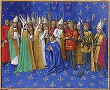
It is said that Philip of Alsace brought the lion flag with him from the Holy Land, where, in 1177, he supposedly conquered it from a Saracen knight, but this is a myth.
During the times of Julius Caesar, the inhabitants were part of the Belgae, a collective name for all Celtic and Germanic tribes in the north of Gaul.
The abandoned coast and Scheldt region had been partially repopulated since the 4th century by Saxons and Franks from the east of the Rhine that retained their Germanic culture and language.
In the 5th century Salic Franks settled in present-day Northern-France and Wallonia, primarily around the cities of Courtrai, Tournai and Bavay.
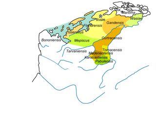
The duchy presumably included the bishoprics of Boulogne, Thérouanne, Arras, Tournai, Cambrai and Noyon: thus, the northwestern region between the North Sea and the Silva Carbonaria, an area the outlines of which were very similar to the later Flanders.
In the area of linguistics, the situation stabilised so that a large, bilingual region with a linear language border could emerge in the 8th century.
The last Merovingian king, Childeric III, was placed in captivity at the later Abbey of Saint Bertinus in St. Omer, and his long hair, a symbol of royal power, was cut off.
Charlemagne succeeded his father Pepin the Short in Neustria and Austrasia, and after the death of his brother Karloman he was able to reunite the entire Frankish Empire.
The region comprising future Flanders was, from an economic point of view, a flourishing region, with a series of ports along the Scheldt river: Ghent, Tournai, Valenciennes, Cambrai and Lambres at Douai on the Scarpe and a number of seaports: Quentovic, Boulogne and Isère portus, a port at the mouth of the Yser.
West Francia, inherited by Charles the Bald, included the original county of Flanders, that spanned roughly between Oudenburg, Aardenburg and Torhout.
The central authorities of the two Frankish kingdoms were unable to organise an effective defensive, causing the population to lose faith and trust in their far-removed rulers.
After mediation by the pope, the Frankish king reconciled with his son-in-law, and gave him the title of margrave, and the corresponding feudal territories as dowry.
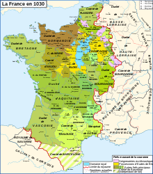
The counts expanded the influence of the original Flemish pagus over the years over all territories south and west of the Scheldt river, including the lordship of the Four Amts, Zeelandic Flanders, the Burgraviate of Aalst [nl] to the east and the County of Artois to the southwest, which remained part of Flanders until it became a separate county in 1237.
After that date, the county of Artois at various times still came under the dominion of the count of Flanders as a separate title, until it was absorbed by the French crown.
[9] Though the majority of Flemish nobles was absent for four years, law and order was kept thanks to the steady leadership of countess Clementia and the advocacy of bishop Lambert of Arras.
The ports of Gravelines, Nieuwpoort, Damme, Biervliet, Dunkirk, and Mardijk were founded, as well as Calais by Philip's brother Matthew of Alsace.
Aside from colonisation, the ports also functioned to reduce the silting of the rivers Aa, Yser and Zwin, which were endangering the accessibility of Saint-Omer, Ypres and Bruges.
These were the centuries of the breakthrough of the Flemish merchants, with their trade with England, the Baltic area and South-West France, as well as the land routes to the Rhineland and Italy though later only the yearly fairs of Champagne.
[13] Flemish prosperity waned in the following century, however, owing to widespread European population decline following the Black Death of 1348, the disruption of trade during the Anglo-French Hundred Years' War (1338–1453), and increased English cloth production.
Through his marriage with Margaret of Dampierre in 1369, Philip the Bold, duke of Burgundy, made an end to the independence of Flanders.
In 1482 this last Burgundian ruler died, making her young son Philip I of Castile of the House of Habsburg the new count, and her husband Maximilian I of Austria the regent.
Under Charles V, Holy Roman Emperor (born in the Flemish city Ghent), Flanders became a member of the Burgundian Circle.
The Beeldenstorm spread through all of the Low Countries and eventually led to the outbreak of the Eighty Years' War and the secession of the Republic of the Seven United Netherlands.
Originally Flanders cooperated with the northern provinces as a member of the Union of Utrecht, and also signed the Act of Abjuration in 1581, but from 1579 to 1585, in the period known as the "Calvinist Republic of Ghent", it was reconquered by the Spanish army.