United States National System of Marine Protected Areas
[1] President Bill Clinton issued Executive Order 13158 in May 2000 for “strengthening the management, protection, and conservation of existing marine protected areas (MPA) and establishment of new or expanded MPAs; the development of a scientifically based, comprehensive national system of MPAs representing diverse U.S. marine ecosystems and the Nation's natural and cultural resources; and the avoiding causing harm to MPAs through federally conducted, approved, or funded activities.”[2] President George W. Bush issued Presidential proclamation 8031 on June 15, 2006 establishing Papahānaumokuākea Marine National Monument.
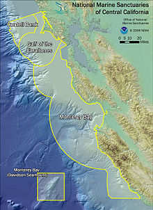
NOAA's national marine protected areas center maintains a comprehensive inventory[5] of all 1,600+ MPAs within the US exclusive economic zone.
In 1999, California adopted the Marine Life Protection Act, the first state law requiring a comprehensive, science-based MPA network.
As a result, the nation's collection of MPAs (e.g., reserves, refuges, preserves, sanctuaries, areas of special biological significance, and others) is fragmented, complex, confusing, and potentially missing opportunities for broader regional conservation through coordinated planning and management.
Presidential Executive Order 13158 was signed by President Bill Clinton on May 26, 2000, directing the Department of Commerce to work with the Department of the Interior, other federal agencies, states, territories, tribes and stakeholders to establish a national system of MPAs to integrate and enhance the nation's MPAs, bringing these diverse sites and programs together to work on common conservation objectives.
MPAs protect ecosystems and resources such as coral reefs, kelp forests, shipwrecks, and those areas frequented by whales and other marine life.
The U.S. has over 1,600 MPAs, ranging from typically small fully protected marine reserves where extractive uses are prohibited to large, multiple-use areas where fishing, diving and other uses are permitted.
The system will benefit the nation's collective conservation efforts and participating MPAs, providing those sites with a means to address issues beyond their boundaries.