Davidson Seamount
Studied only sparsely for decades, NOAA expeditions to the seamount in 2002 and 2006 cast light upon its unique deep-sea coral ecosystem.
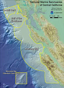
The data gathered during the studies led to the Davidson Seamount being added to the Monterey Bay National Marine Sanctuary in 2008.
All the seamounts in the group are complex northeast-southwest trending structures, consisting of parallel ridges separated by sediment-filled troughs.
The ridges constructed run parallel to an ancient spreading center which has since been replaced in its role by the San Andreas Fault system.
It has in the past been called "An Oasis in the Deep", hosting a vast coral forest, large sponge field, crabs, deep-sea fish, basket stars, and a number of rare benthic species, some of which have yet to be studied properly or even named.
[7] Researchers speculate that Davidson Seamount is an ideal habitat for deep-sea corals and sponges because it has favorable bottom rock (bare lava rock), a steady food supply (supplied by a water current favoring the seamount; see the section above), and has not been disturbed by strong bottom currents than often bother other seafloor areas.
[4] Davidson Seamount was the first underwater volcano to be classified as "seamount" by the United States Board of Geographic Names, in 1938, and was named in honor of the United States Coast and Geodetic Survey scientist George Davidson, one of the key figures in the survey of America's west coast.
The team included scientists, educators, and resource managers, with the goal of documenting species, taking geologic samples, and describing the ocean environment.
[10] The expedition documented many rare, previously undiscovered species that exist nowhere else, not even on nearby seamounts,[4] including ancient coral gardens that are vulnerable to human activity.
[11] Recent expeditions to Davidson have focused on its ecology, and specifically on the variety of deep-sea corals, some over 100 years old, that live on its banks.
Davidson's proximity to scientific research institutions has helped its exploration, as multiple dives, mappings, and studies have made it one of the better-studied seamounts in the world.
[4] In 2006, another exploration, a collaboration of the Monterey Bay National Marine Sanctuary, the Monterey Bay Aquarium Research Institute (MBARI), and Moss Landing Marine Laboratories was undertaken, mainly to test a model that had been developed to predict the availability of coral and to advance the understanding of the seamount's deep-sea coral.
[11] The NOAA outlined a set of 4 goals for the expedition:[12] Scientific data on the water currents and food availability of the seamount was collected, as was information on the age and growth patterns of the corals themselves.
[12] The expedition, which lasted from January 26 through February 4, made use if the MBARI's research vessel Western Flyer and the ROV Tiburon.
[4] The Monterey Bay advisory group concurred with the findings, and submitted its approval to the NOAA, with whom the final decision rested.
[4] In a press release dated November 20, 2008, the NOAA finalized its approval of the plans, and expanded Monterey Bay National Marine Sanctuary by a total of 775 sq mi (2,007 km2) to include Davidson Seamount in its protected area.
[2] In July 2017, under the direction of Executive Order 13795 from President Donald Trump, the U.S. Department of Commerce began re-evaluating the status of the Monterey Bay National Marine Sanctuary, which includes the Davidson Seamount.