Martian spherules
These spherules were discovered on the Martian day that NASA's Mars Exploration Rover Opportunity landed at Meridiani Planum.
They are grey but look bluish next to the ubiquitous rusty reds on Mars, and since the first spherules found in Eagle Crater were 3–6 mm in diameter, the Opportunity team quickly called them "blueberries".
The formation of blueberries required aqueous chemistry and involved flows of acidic, salty, liquid water over the Meridiani Planum and over two geological epochs.
[12][9][13][14][15][16] The Thermal Emission Spectrometer (TES) on the orbiter Mars Global Surveyor first detected crystalline gray hematite (α-Fe2O3) within the Sinus Meridiani.
This green, yellow, and red spot straddles the equator and the prime meridian in the middle of Figure 1a.
[19] In early the 2000s, the hematite map of Figure 1b and the confirmation (from the topography mapping done by the Mars Global Surveyor) that this area is a flat plain and relatively easy to land on were the decisive pieces of evidence for choosing the Meridiani Planum as one of the landing sites for NASA's two bigger Mars Exploration Rovers (MERs), named Opportunity and Spirit.
[20][22] The hematite map of Figure 1b covered part of a larger area called the Sinus Meridiani by 19th-century Mars map-makers.
In 2004, senior scientists for the upcoming MER Opportunity mission introduced the new place name Meridiani Planum for (roughly) the high hematite area in Figure 1b.
[23] NASA'S rover Opportunity successfully made the "hole-in-one" landing into Eagle Crater at Meridiani Planum on January 24(PST), 2004.
Thus, blueberry formation was (broadly) a three-step process: Each of these broad steps involved multiple sub-step processes, described in the following sub-sections: Prior to the formation of Meridiani's defining sediments, in the wet Noachian (named for the biblical Noah) more than about ~3.7 billion years ago, liquid water was present and plentiful enough to form river channels that bought and deposited large quantities of basaltic silt to the current Meridiani region.
[30][31][32] The dried river valleys are easily seen in thermal inertia images taken in orbit by Mars Odyssey and reproduced in Figure 4 (click on it for higher resolution).
[15] The change certainly included aqueous geochemistry that was acidic and salty, as well as rising & falling water levels: Features providing evidence include cross-bedded sediments, the presence of vugs (cavities), and embedded hematite spherules that cut across sediment layers, additionally the presence of large amounts of magnesium sulfate and other sulfate-rich minerals such as jarosite and chlorides.
[13][14] Figures 5 and 6 show Microscopic Imager close-ups of the sediment rock matrix that appeared in a prestigious paper.
[9] Figure 5 illustrates the four physical constituents of sediment outcrop: (i) the sedimentary layers containing a lot of basaltic sand particles; (ii) the embedded hematite spherules; (iii) fine-grained, sulfate-rich cement (in most parts of the outcrop); (iv) vug cavities (that are thought to be molds for crystals of, for example, hydrated sulfates).
Such abrasions showed that (a) the sediment layers are very soft and easy to cut, and (b) the hematite spherules have uniform internal structures.
[9][2][4][35] The diagenetic transformation (i.e., change by water-rock interactions) to today's sediments involved a significant shift in water flows in the region.
The inflows from rivers became less, and the dominant water movements in the sediments became vertical with rising and falling aquifer levels.
[9][15] At least one model of global Martian hydrology accounts for the historical shift in water flows at Meridiani Planum.
[27][42][43][45] Early on, Opportunity's Mössbauer spectrometer took data that determined that the iron mineral component of these spherules is dominated by hematite.
A 2008 paper published the result of a clever experiment that showed Opportunity's mini-TES (thermal emission spectrometer) could not detect any silicate minerals in the spherules.
The Opportunity science team published three papers that studied variations in hematite spherule size.
[3] The Opportunity team found many fragmented blueberries and suggested the fracturing occurred after spherule formation.
Additionally, it suggested simple variations in diagenetic conditions were linked to changes in spherule size.
The third paper made systematic size measurements of hematite spherules embedded in the walls of Victoria Carter at different heights.
These measurements showed a clear variation of spherule size with elevation within the sediments of Meridiani Planum.
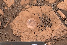
However, the reader can sense how mind-boggling big those numbers are with a photograph of an area of soil with a typical surface density of the hematite spheres.
The parts of the plain Opportunity studied are not special: Compared to the rest of Meridiani Planum, they do not have high surface hematite levels.
The rover Opportunity dug a trench into the top soils that lie over the Meridiani Planum's sediments.