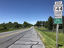
Maryland Route 144
The state highway crosses Evitts Creek before receiving an exit ramp from eastbound I-68 and joins US 220 in a short concurrency.
US 220 turns north onto its bypass of Bedford Road while MD 144 continues east, meeting I-68 at Exit 47, a diamond interchange.
[1][5] Within the interchange, MD 144 becomes National Pike and expands to a four-lane divided highway that follows the valley of Elk Lick Run.
On the climb, MD 144 intersects Pleasant Valley Road, which meets I-68 at Exit 50 and leads to Rocky Gap State Park.
At the top of Martin Mountain, the state highway crosses over I-68 and intersects Sunset Orchard Road, which leads to a ramp to westbound I-68.
On the descent, MD 144 crosses I-68 again and receives a ramp from the eastbound direction of the freeway and the highways part ways around a quarry.
[1][5] MD 144 curves around the quarry and rejoins the side of I-68 as the highway passes West Wilson Road and crosses a tributary of Flintstone Creek.
MD 144 parallels both the Western Maryland Rail Trail and Chesapeake and Ohio Canal National Historical Park one block to the north through the downtown area.
The state highway leaves the town limits and passes the C&O Canal's Hancock visitor center and a park and ride lot before crossing Tonoloway Creek.
The state highway heads east as two-lane undivided Washington Street past farmland, residential subdivisions, and a cemetery.
Patrick Street heads east from the interchange as a four-lane undivided highway that splits into a one-way pair just beyond West College Terrace/Catoctin Avenue.
MD 144 expands to a four-lane undivided street and continues east through an industrial area where the highway intersects Monocacy Boulevard, which is used to access westbound I-70 and Frederick Municipal Airport.
MD 144 reduces to two lanes and veers to the southeast to cross I-70 (Baltimore National Pike), then curves back to the original alignment ahead of ramps to and from eastbound I-70 at the intersection with Quinn Orchard Road.
East of Bartonsville Road, MD 144 expands to a four-lane divided highway, with the westbound direction making use of what to the west was an unused carriageway.
The original alignment continues straight to a dead end while the state highway turns north and then east to its eastern terminus at MD 75 (Green Valley Road), which is used to access I-70.
The state highway, known as Frederick Road, immediately turns north and after 0.07 miles (0.11 km) crosses the Frederick–Carroll County line.
[1] MD 144 passes Parr's Spring, the source of the Patapsco River, before curving to the east through residential subdivisions and closely paralleling the eastbound lanes of I-70.
[1] Shortly after crossing the Patapsco River and entering Howard County, the state highway veers away from the freeway and passes through a mix of farmland and scattered residences.
[1][10] Frederick Road splits off from US 40 as a county highway about 1 mile (1.6 km) east of the eastern end of the Mount Airy – Ellicott City portion of MD 144.
[11] MD 144 begins at the county line as two-lane undivided Frederick Road, where the state highway passes through the Ellicott's Mills Historic District.
MD 144 continues east through a densely populated residential area, intersecting North Rolling Road and entering Catonsville, where the highway intersects MD 166 (South Rolling Road), which heads south toward the University of Maryland Baltimore County and Baltimore/Washington International Thurgood Marshall Airport (via I-195).
At the eastern end of the central business district, MD 144 passes Wade Avenue, which heads south to Spring Grove Hospital Center, before meeting I-695 (Baltimore Beltway) at a diamond interchange.
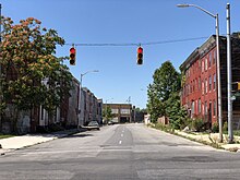
The state highway continues east through a less affluent series of neighborhoods where it crosses over Gwynns Falls and CSX's Hanover Subdivision railroad line.