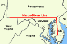
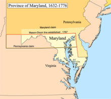
Mason–Dixon line
It was surveyed between 1763 and 1767 by Charles Mason and Jeremiah Dixon as part of the resolution of a border dispute involving Maryland, Pennsylvania, and Delaware in the colonial United States.
This usage came to prominence during the debate around the Missouri Compromise of 1820, when drawing boundaries between slave and free territory[2] and resurfaced during the American Civil War, with border states also coming into play.
Mason and Dixon's actual survey line began to the south of Philadelphia, and extended from a benchmark east to the Delaware River and west to what was then the boundary with western Virginia.
[9] Mason and Dixon also confirmed the earlier survey delineating Delaware's southern boundary from the Atlantic Ocean to the "Middle Point" stone (along what is today known as the Transpeninsular Line).
Both sides agreed that Pennsylvania's grant made its western border a tracing of the course of the Delaware River, displaced five degrees (approximately 265 miles) to the west.
To compensate Pennsylvania for the claimed territory lost, its western boundary would be run due north rather than copying the course of the Delaware River.
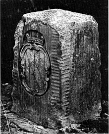
[citation needed] The lines have been resurveyed several times over the centuries without substantive changes to Mason's and Dixon's work, and additional benchmarks and survey markers were placed where necessary.
Pennsylvania's grant defined the colony's southern boundary as following a 12-mile (radius) circle (19 km) counter-clockwise from the Delaware River until it hit "the beginning of the fortieth degree of Northern latitude."
They were commissioned to run it for a distance of five degrees of longitude west from the Delaware River, fixing the western boundary of Pennsylvania (see the entry for Yohogania County).
However, in October 1767, at Dunkard Creek near Mount Morris, Pennsylvania, nearly 244 miles (393 km) west of the Delaware, their Iroquois guides refused to go any further, having reached the border of their lands with the Lenape, with whom they were engaged in hostilities.
[19] In 1784, surveyors David Rittenhouse and Andrew Ellicott and their crew completed the survey of the Mason–Dixon line to the southwest corner of Pennsylvania, five degrees from the Delaware River.
[22] As the 20th century moved along and modern roadways came to northeastern Maryland and Delaware, the old boundary line was noted by construction crews, newspaper columnists, and the traveling public.
When contractors started working on a section of Route 40, a modern dual highway between Elkton and Glasgow, they discovered a time and weather battered original Mason Dixon Marker.
But long before bulldozers and other heavy equipment started moving earth for the dual highway before World War II, there were concerns about the preservation of this monument.
After the president, flanked by the governors of Delaware and Maryland, cut a ribbon opening the Interstate, they moved to the grassy median strip where a replica Mason and Dixon Marker had been placed for the bicentennial.
[26] There was keen interest in their work and much communication between the surveyors, Maskelyne and other members of the British Scientific establishment in the Royal Society in Britain, notably Henry Cavendish.
[32] When this information got back to the Royal Society members, Henry Cavendish realised that this may have been due to the gravitational pull of the Allegheny Mountains deflecting the theodolite plumb-bobs and spirit levels toward them to the west.
[33][34] Maskelyne then proposed measuring the gravitational force causing this deflection induced by the pull of a nearby mountain upon a plumb-bob in 1772 and sent Mason (who had returned to Britain) on a site survey through central England and Scotland to find a suitable location during the summer of 1773.
Technically, that demarcation did not extend beyond Pennsylvania where Virginia, Maryland, and Delaware, all slave states, lay south or east of the boundary.
Also lying north and east of the boundary was New Jersey, where slavery was formally abolished in 1846, but former slaves continued to be "apprenticed" to their masters until the passage of the Thirteenth Amendment to the United States Constitution in 1865.
The Missouri Compromise line (Parallel 36°30′ north) had a much clearer geographic connection to slavery in the United States leading up to the Civil War.