Mato Grosso do Sul
'South Thick Bush') is one of Brazil's 27 federal units, located in the southern part of the Central-West Region, bordering five Brazilian states: Mato Grosso (to the north), Goiás and Minas Gerais (northeast), São Paulo (east) and Paraná (southeast); and two South American countries: Paraguay (south and southwestern) and Bolivia (west).
The Pantanal lowlands cover 12 municipalities and presents a variety of flora and fauna, with forests, natural sand banks, savannahs, open pasture, fields and bushes.
The "cerrado" landscape is characterized by extensive savanna formations crossed by gallery forests and stream valleys.
The "cerrado" trees have characteristic twisted trunks covered by a thick bark, and leaves which are usually broad and rigid.
The plant's thick bark and roots serve as adaptations for the periodic fires which sweep the cerrado landscape.
In the 1630s, the Jesuits also established short-lived missions among the Guaraní people in the Itatín region of present-day Mato Grosso do Sul, Brazil.
[7] In the Cerrado areas, mostly in the south, central and east, there is a predominance of Southern Brazilian farmers of Spanish, German, Portuguese, Italian and Slavic descent.
According to an autosomal DNA study from 2008, the ancestral composition of Mato Grosso do Sul is 73,60% European, 13,90% African and 12,40% Native American.
[8] Additionally, according to a different 2013 DNA study, the ancestral composition of Mato Grosso do Sul is: 58.8% European, 25.9% Amerindian and 15.3% African ancestries, respectively.
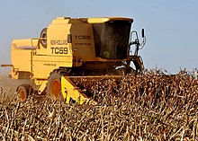
Mato Grosso do Sul exports: soybeans 34.9%, pork and chicken 20.9%, beef 13.7%, ores 8%, leather 7.4%, timber 5.1% (2002).
Between 2010 and 2018, production in the south of Mato Grosso increased by 308%, reaching 17 million cubic meters of round wood for paper and cellulose in 2018.
[26][27] The state also has two railway lines: the Estrada de Ferro Noroeste do Brasil, which connects the center-west of the state of São Paulo with the city of Corumbá, in Mato Grosso do Sul, on the Paraguay River, with 1,330 kilometers in length; and Ferrovia Norte Brasil, which has connected the city of Santa Fé do Sul with Rondonópolis since 1989, being one of the main corridors for the flow of grain in the region, with 755 kilometers connect the northwest of São Paulo with the south of Mato Grosso.
The main products transported by the river are: iron and manganese ores, cement, wood, petroleum derivatives and cattle.
Its main attractions are the natural landscapes, and the immersions in rivers of transparent waters, waterfalls, caves and sinkholes.
Along with Jardim, Guia Lopes da Laguna and Bodoquena, it is the main municipality that integrates the region's tourist complex.
A white stripe divides an upper left green corner from a bottom right blue space with a yellow star.
White symbolizes hope, green is an allusion to the state's rich flora, blue represents its vast sky, while the yellow star adds balance, force and serenity.