Maumee River
It is formed at the confluence of the St. Joseph and St. Marys rivers, where Fort Wayne, Indiana has developed, and meanders northeastwardly for 137 miles (220 km)[4] through an agricultural region of glacial moraines before flowing into the Maumee Bay of Lake Erie.
After this decisive victory for General Anthony Wayne, in 1795 Native Americans ceded a twelve-mile square tract around Perrysburg and Maumee to the United States by the Treaty of Greenville.
A dispute over control of part of the Maumee River region led to the so-called Toledo War between Ohio and the Michigan Territory.
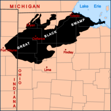
The 1,500-square-mile (3,900 km2) swamp was a vast network of forests, wetlands, and grasslands, a rich habitat for numerous species of birds, mammals, fish and flora.
During the 19th century, European-American settlers struggled to drain the swamp and to convert the land to farmland; they dramatically altered the habitat, reducing areas where species could flourish.
The mouth of the river at Toledo and Lake Erie is wide and supports considerable commercial traffic, including oil, grain, and coal.
About 12 miles (19 km) upstream, in the town of Perrysburg, Ohio, the river becomes much shallower and today supports only recreational navigation above that point.
The Miami and Erie Canal was built parallel to and north of the Maumee between Toledo and Defiance, Ohio, to enable extended transportation of shipped goods.
[12] A 2006 remedial action plan for the AOC identified 10 "beneficial use impairments" caused by the pollution: There are several small islands in the section of the Maumee River in northwest Ohio.