2009 Super Derecho
[9][10] Thirty-nine tornadoes, including two of EF3 strength on the Enhanced Fujita Scale, were reported in addition to high non-tornadic winds associated with the derecho and MCV.
[2] A wind gust of 106 mph (171 km/h) was recorded by a backup anemometer at the Southern Illinois Airport after official National Weather Service equipment failed.
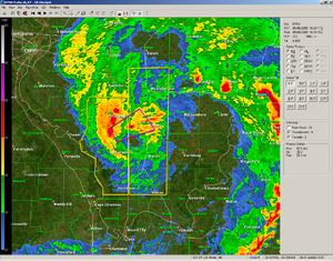
[15] The cluster of storms began to evolve into a more organized derecho near Hutchinson, Kansas, where National Weather Service damage surveys found winds greater than 100 mph (160 km/h) started, then continued through southern Missouri.
[1][3] As the derecho entered southeastern Missouri, the initial line associated began to weaken, but the MCV became increasingly pronounced on the northern end.
[20][21] As both the initial squall line and MCV weakened, very little severe weather was reported between southern Illinois and central Kentucky.
[22] However, as the weakening squall line encountered higher instability and more favorable upper-level winds, the line split into several supercells in a process still not fully understood;[23] these storms produced several tornadoes in central Kentucky, eastern Tennessee, southwestern Virginia, and northwestern North Carolina.
[24][25] While no longer producing severe weather itself, the MCV continued to enhance thunderstorms early the next morning across southeastern Virginia.
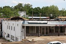
[7] National Weather Service survey teams found that winds reached 120 mph (190 km/h) in the area, which also resulted in the destruction of a church and the town's post office, in addition to damaging several homes.
[1] A long-lived supercell formed within the MCV in Madison County, Missouri, producing hail up to baseball size and a few tornadoes, in addition to the more widespread, damaging, straight-line winds throughout the area.
As the MCV crossed the Mississippi River and entered into more populated areas, it strengthened greatly, while it nearly separated from the initial line.
Marion, Murphysboro, Grand Tower, Johnston City, Herrin, Energy, and Carterville, Illinois, declared curfews and states of emergency due to power outages and the massive amounts of damage caused by the storms.
One mobile phone bill from a damaged house was carried 35 miles (56 km) before coming to rest on the property of a National Weather Service employee.
[59] Flowing water over the Kansas Turnpike forced officials to shut down a 20 mi (32 km) stretch of the highway for over an hour.
[66] More significant flooding took place in St. Francois County, where some homes had up to 8 ft (2.4 m) of water in their basements and railroads were partially washed out.
Several other structures in the area were also inundated during the storm, and two people needed to be rescued from their vehicle, which was stalled in waist-deep water.
[70] On July 2, 2009, President Barack Obama declared a major disaster in Franklin, Gallatin, Jackson, Randolph, Saline, and Williamson counties in Illinois; Dolph A. Diemont was named as the Federal Emergency Management Agency coordinating officer for the area.
In addition, it was announced that the Citizens Electric Corporation would receive a $1,395,201.46 grant to offset costs incurred in repairing infrastructure in Perry, Sainte Genevieve, and Cape Girardeau counties.