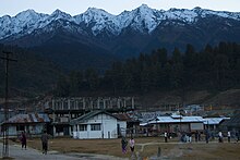
Mechuka
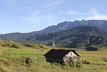
& 'Kha' means Snow; Meaning "the land blessed with medicinal snow-fed water- river & streams") is a town, assembly constituency and subdivision, situated 6,000 feet (1,829 m) above sea level in the Mechukha Valley of Yargep Chu/ Siyom River in Shi Yomi district of Arunachal Pradesh state of India.
Prior to the construction of the modern road, the only access to the village was via an airstrip, used by the Indian Air Force to supply goods to local people.
During those times, Membas (adi)ramo people used to trade with Tibet like Mithun for salt and medicines.
The largest tribe of the Shi Yomi district is (Adi) Bokar, mainly residing in the Monigong circle, Memba inhabiting the valleys of Mechukha, limbo and Ramo inhabiting the Tato circle; most of the people speak Adi in the Shi Yomi district after that member and then tagin.
[7] Government of Arunachal Pradesh has invited bids from the private airlines to operate a 9-seater fixed-wing air service which will not be under the UDAN scheme (c. May 2018).
Mechukha has recently been connected by a strategic road to Tato and Aalo (formerly called Along), leading to increased development in the area.
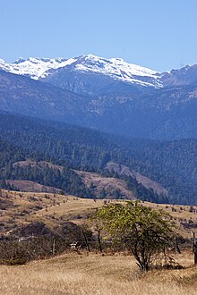
[13] Mechukha is gradually becoming a popular tourist destination in Arunachal Pradesh due to its scenic beauty, exotic tribes, gentle hills and snow-capped mountains and Siyom River (locally known as Yargyap Chu).
[14] The major tourist attraction here is a 400-year-old Buddhist Monastery, which is located at a hilltop in the westernmost part of Mechukha.
The people of Adi tribe have resided in the Menchukha valley since time immemorial in the periphery of Mechukha valley in the villages of Gapo, Pauk, Padusa, Lipusi, Hiri, Purying, Rapum, Charung, Rego and Kart gumjipang, barang gang, shorang dhem, etc.