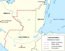
Guatemala–Mexico border
In 1881, problems arose for Guatemala when President Justo Rufino Barrios claimed lands in Soconusco and Chiapas.
However, from 1882 began talks to resolve the problem between Matías Romero and Justo Rufino at The Winch at Hacienda de Barrios (Soconusco), where both had possessions.
The preliminary agreement was signed in New York City on 12 August 1882, and it stated that: "The Republic of Guatemala dispenses with the argument that has held about his rights to the territory of Chiapas and Soconusco department."
As for the delineation of the border itself, Mexico and Guatemala agreed to use straight lines between key points known and accepted by both countries.
Additionally, Contreras found that at coffee farms in the state of Chiapas, "40,000 Guatemalan field hands endure backbreaking jobs and squalid living conditions to earn roughly [US]$3.50 a day" and that some farmers "even deduct the cost of room and board from that amount.
[3] The plan proposes "to overcome common challenges related to migration and respect for human rights" and to establish "a more modern, efficient, prosperous and secure border.