Middle Level Navigations
The Middle Level Navigations are a network of waterways in England, primarily used for land drainage, which lie in The Fens between the Rivers Nene and Great Ouse, and between the cities of Peterborough and Cambridge.
The Middle Level was given its name by the Dutch Engineer Cornelius Vermuyden in 1642, who subsequently constructed several drainage channels to make the area suitable for agriculture.
Water levels were always managed to allow navigation, and Commissioners were established in 1754 to maintain the waterways and collect tolls from commercial traffic.
The Middle Level Main Drain to Wiggenhall St Germans was completed in 1848, which provided better drainage because the outfall was lower than that at Salters Lode.
Whittlesey Mere, the last remaining lake, was drained soon afterwards, using one of the first applications of John Appold's centrifugal pump, following its appearance at the Great Exhibition in 1851.
[1] Attempts to protect them from inundation and to make them suitable for agriculture began in 1480, when the Bishop of Ely, John Morton, constructed a 12-mile (19 km) straight cut from Stanground to Guyhirne.
The Old Bedford River was cut from Earith to Salters Lode, a distance of 21 miles (34 km), and provided sufficient drainage that the land could be used for summer grazing.
To the north is Well Creek, most of which was a natural waterway,[4] although the final section to Salters Lode Lock follows the course of the New Podyke, a drainage channel constructed in the early sixteenth century.
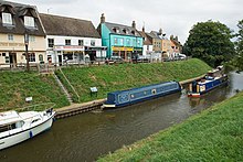
Agricultural produce was carried through Salters Lode, bound for Kings Lynn, while coal, timber and groceries moved in the opposite direction.
Pleasure boats were specifically excluded from paying tolls, as were certain products including manure, compost, malt dust, pigeons' dung and some varieties of oil cake.
[6] Another account of the system is provided by George Walpole's Journal of the Voyage round the Fens in 1774, which was made in a fleet of nine boats, all of which were towed by a single horse called Hippopotamus when there was insufficient wind for sailing.
Carpenters were employed to jack up or remove bridges which were too low for the boats to pass, and although the expedition lasted for 22 days, Walpole only recorded one gang of lighters, which delayed them as Salters Lode.
[1] The work was completed in 1848,[9] and the sluice at Marmount Priory was also built at this time, in order to allow boats with a deeper draught to navigate through Upwell and Outwell.
Sir John Hawkshaw constructed a new sluice, consisting of a large cofferdam, with 16 tubes, each 3 feet 6 inches (1.1 m) in diameter, which passed over the top of it.
It was the only time that such a solution was tried in the Fens, and it was supplemented in 1880 by a more conventional gravity sluice, also constructed by Hawkshaw, as it was unable to discharge sufficient water.
[9] Some commercial traffic on the waterways continued despite the railway competition, with 44,034 tons generating £733 of tolls in 1888, which enabled the Commissioners to show a profit of £216.
An Alderman giving evidence to the Royal Commission on Canals and Waterways in 1905 pointed out that one of the railway companies had been paying to collect traffic in hay and straw, although this practice ceased when it became public knowledge.
The condition of the Nene and the Wisbech Canal declined, which discouraged navigation, but some trade in agricultural produce, coal, bricks and road building materials continued.
By the late 1920s, gravity discharge alone could no longer be relied upon to provide an adequate level of flood protection, and a change to pumped drainage began.
[14] From 1977 to 1983, a series of improvements were carried out, which included the construction of a pumping station at Tebbits Bridge on Bevills Leam, preventing navigation along this channel to the southern reaches of the Middle Levels.
The Inland Waterways Association raised the funding for the additional materials required, and the reconstruction opened up a 33-mile (53 km) cruising ring on the Levels.
The suggested route passes through Stanground Sluice, along King's Dyke to Ashline Lock, and then along Whittlesey Dike to Flood's Ferry junction.
The final stretch to Salters Lode lock is along Well Creek, passing over the top of the Middle Level Main Drain on Mullicourt Aqueduct.
[24] The alternative route via Horseway sluice and the Old Bedford River is unusable, as the lock at Welches Dam was declared unsafe and closed in 2006, and a reedbed has taken hold.