Ural Mountains
[1] The mountain range forms part of the conventional boundary between the continents of Europe and Asia, marking the separation between European Russia and Siberia.
During the next few centuries, the Novgorodians engaged in fur trading with the local population and collected tribute from Yugra and Great Perm, slowly expanding southwards.
Ivan III, the grand prince of Moscow, captured Perm, Pechora and Yugra from the declining Novgorod Republic in 1472.
[13] Nevertheless, around the early 16th century, Polish geographer, Maciej of Miechów, in his influential Tractatus de duabus Sarmatiis (1517) argued that there were no mountains in Eastern Europe at all, challenging the point of view of some authors of Classical antiquity, which were popular during the Renaissance.
In the 1550s, after the Tsardom of Russia had defeated the Khanate of Kazan and proceeded to gradually annex the lands of the Bashkirs, the Russians finally reached the southern part of the mountain chain.
The upper reaches of the Kama and Chusovaya in the Middle Ural, still unexplored, as well as parts of Transuralia still held by the hostile Siberian Khanate, were granted to the Stroganovs by several decrees of the tsar in 1558–1574.
Customs was established in Verkhoturye shortly thereafter and the road was made the only legal connection between European Russia and Siberia for a long time.
Transportation of the output of the smelting works to the markets of European Russia necessitated the construction of the Siberian Route from Yekaterinburg across the Ural to Kungur and Yegoshikha (Perm) and further to Moscow, which was completed in 1763 and rendered Babinov's road obsolete.
[16] During the Soviet industrialization in the 1930s, the city of Magnitogorsk was founded in the South-Eastern Ural as a center of iron smelting and steelmaking.
During the German invasion of the Soviet Union in 1941–1942, the mountains became a key element in Nazi planning for the territories which they expected to conquer in the USSR.
Faced with the threat of having a significant part of the Soviet territories occupied by the enemy, the government evacuated many of the industrial enterprises of European Russia and Ukraine to the eastern foothills of the Ural, considered a safe place out of reach of the German bombers and troops.
After the war, in 1947–1948, Chum – Labytnangi railway, built with the forced labor of Gulag inmates, crossed the Polar Ural.
Mayak, 150 kilometres (93 mi) southeast of Yekaterinburg, was a center of the Soviet nuclear industry[1][17][18][19] and site of the Kyshtym disaster.
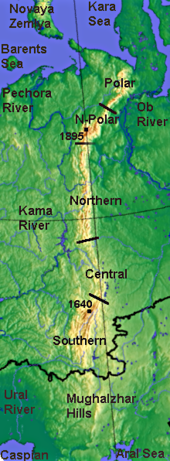
[18][20] The Ural Mountains extend about 2,500 km (1,600 mi) from the Kara Sea to the Kazakh Steppe along the border of Kazakhstan.
[2] By topography and other natural features, the Urals are divided, from north to south, into the Polar (or Arctic), Nether-Polar (or Sub-Arctic), Northern, Central and Southern parts.
The mountains of the Polar Ural have exposed rock with sharp ridges, though flattened or rounded tops are also found.
[21][22][23][24] Unlike the other major orogens of the Paleozoic (Appalachians, Caledonides, Variscides), the Urals have not undergone post-orogenic extensional collapse and are unusually well preserved for their age, being underlaid by a pronounced crustal root.
The sediments to the west of the Ural Mountains are formed of limestone, dolomite and sandstone left from ancient shallow seas.
The eastern slopes are relatively flat, with some hills and rocky outcrops and contain alternating volcanic and sedimentary layers dated to the middle Paleozoic Era.
The Western Urals contain deposits of coal, oil, natural gas (Ishimbay and Krasnokamsk areas) and potassium salts.
The specialty of the Urals is precious and semi-precious stones, such as emerald, amethyst, aquamarine, jasper, rhodonite, malachite and diamond.
[27] The eastern slopes of the Southern and Central Urals have most of these, among the largest of which are the Uvildy, Itkul, Turgoyak, and Tavatuy lakes.
Reptiles and amphibians live mostly in the Southern and Central Ural and are represented by the common viper, lizards and grass snakes.
The continuous and intensive economic development of the last centuries has affected the fauna, and wildlife is much diminished around all industrial centers.
During World War II, hundreds of factories were evacuated from Western Russia before the German occupation, flooding the Urals with industry.
The area has also been severely damaged by the plutonium-producing facility Mayak, opened in Chelyabinsk-40 (later called Chelyabinsk-65, Ozyorsk), in the Southern Ural, after World War II.
[1] Its plants went into operation in 1948 and, for the first ten years, dumped unfiltered radioactive waste into the river Techa and Lake Karachay.
[28] The Urals have been viewed by Russians as a "treasure box" of mineral resources, which were the basis for its extensive industrial development.
In addition to iron and copper, the Urals were a source of gold, malachite, alexandrite, and other gems such as those used by the court jeweller Fabergé.
Dmitry Mamin-Sibiryak (1852–1912) and Pavel Bazhov (1879–1950), as well as Aleksey Ivanov and Olga Slavnikova, post-Soviet writers, have written of the region.