Mie Prefecture
[2] Mie Prefecture has a population of 1,781,948 (as of 1 June 2019[update]) and has a geographic area of 5,774 square kilometers (2,229 sq mi).
[3]: 995 Mie Prefecture is located on the eastern coast of the Kii Peninsula, forming the western side of Ise Bay which features the mouths of the Kiso Three Rivers.
After the Meiji Restoration, the former provinces of Ise, Shima and Iga as well as a portion of eastern Kii, were organized and reorganized repeatedly.
Crops were destroyed, sea walls ruined, roads and railways damaged and a substantial number of people were injured or left homeless.
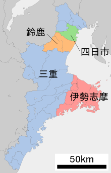
Mie Prefecture forms the eastern part of the Kii Peninsula, and borders on Aichi, Gifu, Shiga, Kyoto, Nara, and Wakayama.
Southern Mie, south of the Shima Peninsula, has a warmer Pacific marine climate, with Owase Region having one of the heaviest rainfall figures for all of Japan.
[5] As of 31 March 2019,[update] 36% of the total area of the prefecture comprised designated Natural Parks,[6] namely: Since 2006, Mie consists of 29 municipalities: 14 cities and 15 towns.
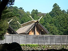
Mie Prefecture has traditionally been a link between east and west Japan, thanks largely to the Tokaido and Ise Pilgrimage Roads.
Ignoring small changes through cross-prefectural municipal mergers, neighbourhood transfers and coastline variations, Mie reached its present borders in 1876 when it absorbed Watarai Prefecture.
In the last round in 2019, governor Eikei Suzuki easily won a third term with broad support from LDP, Shinsei Mie (see below) and Kōmeitō, against only one, JCP-supported challenger;[16] Suzuki was originally elected narrowly in 2011 as centre-right candidate against centre-left supported Naohisa Matsuda, former mayor of Tsu City.
After the national elections of 2016, 2017 and 2019, Mie's directly elected delegation was evenly split between Liberal Democrats (HR district #1: Norihisa Tamura, #4: Noriyo Mitsuya, HC 2019–25 class: Yūmi Yoshikawa) and ex-Democrats (HR #2: Masaharu Nakagawa, #3: Katsuya Okada, HC 2016–22 class: Hirokazu Shiba) in both houses of the Diet.